Jump to navigationJump to search
Size of this PNG preview of this SVG file: 671 × 599 pixels. Other resolutions: 269 × 240 pixels | 538 × 480 pixels | 672 × 600 pixels | 860 × 768 pixels | 1,147 × 1,024 pixels | 2,293 × 2,048 pixels | 720 × 643 pixels.
Original file (SVG file, nominally 720 × 643 pixels, file size: 2.23 MB)
| This is a file from the Wikimedia Commons. Information from its description page there is shown below. Commons is a freely licensed media file repository. You can help. |
Summary
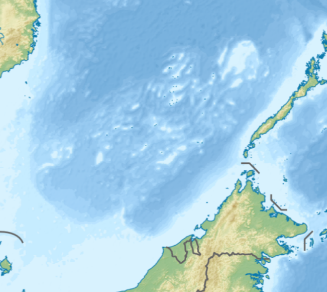
| Description | English: Location map of the Spratly Islands relief N-S stretching 102.0004% in SVG file. Geographic limits of the map:
|
| Date | |
| Source | Own work |
| Author | LuciferAhriman |
| Other versions |
|

Licensing
I, the copyright holder of this work, hereby publish it under the following license:
| This file is licensed under the Creative Commons Attribution-Share Alike 4.0 International license. | |
|
File history
Click on a date/time to view the file as it appeared at that time.
| Date/Time | Thumbnail | Dimensions | User | Comment | |
|---|---|---|---|---|---|
| current | 08:47, 17 October 2020 |  | 720 × 643 (2.23 MB) | LuciferAhriman | Uploaded own work with UploadWizard |
File usage
The following pages on the English Wikipedia use this file (pages on other projects are not listed):
- Amboyna Cay
- Ardasier Reef
- Bombay Castle (South China Sea)
- Collins Reef
- Commodore Reef
- Cornwallis South Reef
- Dallas Reef
- Erica Reef
- First Thomas Shoal
- Flat Island (South China Sea)
- Half Moon Shoal
- Investigator Shoal
- Irving Reef
- James Shoal
- Ladd Reef
- Lankiam Cay
- Loaita Cay
- Loaita Island
- Louisa Reef
- Mariveles Reef
- Namyit Island
- Nanshan Island
- Northeast Cay
- Northeast Investigator Shoal
- Royal Captain Shoal
- Sabina Shoal
- Sand Cay
- Second Thomas Shoal
- Sin Cowe Island
- Southwest Cay
- Spratly Island
- Swallow Reef
- Third Thomas Shoal
- Thitu Island
- West York Island
- Western Reef
- Module:Location map/data/Spratly Islands relief
- Module:Location map/data/Spratly Islands relief/doc
Global file usage
The following other wikis use this file:
- Usage on zh.wikipedia.org
- Template:Location map Spratly Islands
- Template:Location map Spratly Islands relief
- Module:Location map/data/Spratly Islands relief
- Module:Location map/data/Spratly Islands relief/doc