Jump to navigationJump to search

Size of this PNG preview of this SVG file: 342 × 599 pixels. Other resolutions: 137 × 240 pixels | 274 × 480 pixels | 342 × 600 pixels | 438 × 768 pixels | 584 × 1,024 pixels | 1,168 × 2,048 pixels | 639 × 1,120 pixels.
Original file (SVG file, nominally 639 × 1,120 pixels, file size: 2.56 MB)
| This is a file from the Wikimedia Commons. Information from its description page there is shown below. Commons is a freely licensed media file repository. You can help. |
Summary
| Description | English: Relief location map of New Hampshire, USA Geographic limits of the map:
|
| Date | |
| Source | Own work
|
| Author | SANtosito |
| Other versions |  |
Licensing
I, the copyright holder of this work, hereby publish it under the following license:
| This file is licensed under the Creative Commons Attribution-Share Alike 4.0 International license. | |
|
File history
Click on a date/time to view the file as it appeared at that time.
| Date/Time | Thumbnail | Dimensions | User | Comment | |
|---|---|---|---|---|---|
| current | 03:49, 2 February 2021 | 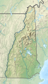 | 639 × 1,120 (2.56 MB) | SANtosito | Uploaded own work with UploadWizard |
File usage
More than 100 pages use this file. The following list shows the first 100 pages that use this file only. A full list is available.
- Akers Pond
- Arlington Mill Reservoir
- Ashuelot Pond
- Ayers Island Reservoir
- Baboosic Lake
- Back Lake (New Hampshire)
- Baker River (New Hampshire)
- Baxter Lake (New Hampshire)
- Bellamy Reservoir
- Bellamy River
- Bow Lake (New Hampshire)
- Broad Bay (New Hampshire)
- Canaan Street Lake
- Charlestown (CDP), New Hampshire
- Cobbetts Pond
- Cochecho River
- Comerford Reservoir
- Concord, New Hampshire
- Connecticut Lakes
- Contoocook Lake
- Contoocook River
- Conway Lake
- Country Pond
- Crotched Mountain
- Crystal Lake (Enfield, New Hampshire)
- Crystal Lake (Gilmanton, New Hampshire)
- Dan Hole Pond
- Dartmouth Skiway
- Deering Reservoir
- East Peak Mount Osceola
- Eastman Pond
- Exeter River
- Franklin Pierce Lake
- Goose Pond (New Hampshire)
- Grafton Pond
- Great East Lake
- Greenough Pond
- Halfmoon Lake (Barnstead, New Hampshire)
- Highland Lake (Stoddard, New Hampshire)
- Indian Stream
- Isinglass River
- Island Pond (Rockingham County, New Hampshire)
- Israel River
- Johns River (New Hampshire)
- Lake Francis (Murphy Dam)
- Lake Kanasatka
- Lake Massabesic
- Lake Massasecum
- Lake Monomonac
- Lake Wentworth
- Lake Winnipesaukee
- Lake Winnisquam
- Lakes of the Clouds
- Lamprey River
- Lebanon Municipal Airport (New Hampshire)
- Little Squam Lake
- Little Sunapee Lake
- Loon Mountain
- Lovell Lake
- Manchester, New Hampshire
- Manchester–Boston Regional Airport
- Mascoma Lake
- Mascoma River
- McIndoes Reservoir
- Mendum's Pond
- Merrymeeting Lake
- Mohawk River (New Hampshire)
- Moore Reservoir
- Mount Adams (New Hampshire)
- Mount Blue (New Hampshire)
- Mount Chocorua
- Mount Lafayette
- Mount Lincoln (New Hampshire)
- Mount Madison
- Mount Monadnock
- Mount Monroe
- Mount Washington
- Mount Washington Regional Airport
- Nash Stream
- Nashua River
- Newfound Lake
- Ossipee Lake
- Oyster River (New Hampshire)
- Paugus Bay
- Pemigewasset River
- Phillips Brook
- Portsmouth International Airport at Pease
- Province Lake
- Rhododendron State Park
- Rollins State Park
- Saco River
- Salmon Falls River
- Sebbins Pond
- Silver Lake (Hollis, New Hampshire)
- Silver Lake State Park (New Hampshire)
- Souhegan River
- Squam Lake
- Squamscott River
- Tuxbury Pond
- Umbagog Lake
View more links to this file.
Global file usage
The following other wikis use this file:
- Usage on nl.wikipedia.org
- Sjabloon:Positiekaart New Hampshire
- Presidential Range
- Lake Winnipesaukee
- Profile Lake
- Merrymeeting Lake
- Lake Tarleton
- Lake Sunapee
- Silver Lake (Hollis, New Hampshire)