Harz
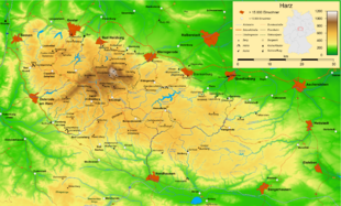
The Harz (German: [haːɐ̯ts] (listen)![]() ) is a highland area in northern Germany. It has the highest elevations for that region, and its rugged terrain extends across parts of Lower Saxony, Saxony-Anhalt, and Thuringia. The name Harz derives from the Middle High German word Hardt or Hart (hill forest), Latinized as Hercynia. The Brocken is the highest summit in the Harz with an elevation of 1,141.1 metres (3,744 ft) above sea level. The Wurmberg(971 metres (3,186 ft)) is the highest peak located entirely within the state of Lower Saxony.
) is a highland area in northern Germany. It has the highest elevations for that region, and its rugged terrain extends across parts of Lower Saxony, Saxony-Anhalt, and Thuringia. The name Harz derives from the Middle High German word Hardt or Hart (hill forest), Latinized as Hercynia. The Brocken is the highest summit in the Harz with an elevation of 1,141.1 metres (3,744 ft) above sea level. The Wurmberg(971 metres (3,186 ft)) is the highest peak located entirely within the state of Lower Saxony.
The Harz has a length of 110 kilometres (68 mi), stretching from the town of Seesen in the northwest to Eisleben in the east, and a width of 35 kilometres (22 mi). It occupies an area of 2,226 square kilometres (859 sq mi), and is divided into the Upper Harz (Oberharz) in the northwest, which is up to 800 m high, apart from the 1,100 m high Brocken massif, and the Lower Harz (Unterharz) in the east which is up to around 400 m high and whose plateaus are capable of supporting arable farming.
The following districts (Kreise) fall wholly or partly within the Harz: Goslar and Göttingen in the west, Harz and Mansfeld-Südharz in the north and east, and Nordhausen in the south. The districts of the Upper Harz are Goslar and Göttingen (both in Lower Saxony), whilst the Lower Harz is on the territory of Harz and Mansfeld-Südharz districts (both in Saxony-Anhalt). The Upper Harz is generally higher and features fir forests, whilst the Lower Harz gradually descends into the surrounding area and has deciduous forests interspersed with meadows.
The dividing line between Upper and Lower Harz follows approximately a line from Ilsenburg to Bad Lauterberg, which roughly separates the catchment areas for the Weser (Upper Harz) and Elbe (Lower Harz). Only on the southeastern perimeter of the Upper Harz, which is also called the High Harz (Hochharz) (Goslar, Göttingen and Harz districts), does the mountain range exceed 1,000 m above NN on the Brocken massif. Its highest peak is the Brocken (1,141 m), its subsidiary peaks are the Heinrichshöhe (1,044 m) to the southeast and the Königsberg (1,023 m) to the southwest. Other prominent hills in the Harz are the Acker-Bruchberg ridge (927 m), the Achtermannshöhe (925 m) and the Wurmberg (971 m) near Braunlage. In the far east, the mountains merge into the East Harz foothills (Harz district, Saxony-Anhalt), which are dominated by the Selke Valley. Part of the south Harz lies in the Thuringian district of Nordhausen.
The Harz National Park is located in the Harz; the protected area covers the Brocken and surrounding wilderness area. Approximately 600,000 people live in towns and villages of the Harz Mountains.
Because of the heavy rainfall in the region the rivers of the Harz Mountains were dammed from an early date. Examples of such masonry dams are the two largest: the Oker Dam and the Rappbode Dam. The clear, cool water of the mountain streams was also dammed by early mountain folk to form the various mountain ponds of the Upper Harz waterways, such as the Oderteich.


