
Соединенные Штаты Америки был создан 4 июля 1776 года, с Декларацией независимости от тринадцати британских колоний в Северной Америке . В резолюции Ли от 2 июля 1776 г. колонии решили, что они являются свободными и независимыми государствами. Союз был официально оформлен статьями Конфедерации , которые вступили в силу 1 марта 1781 года после ратификации всеми 13 штатами. Их независимость была признана Великобританией в Парижском договоре 1783 года, которым завершилась Война за независимость США.. Это фактически удвоило размер колоний, которые теперь могут простираться на запад, мимо Линии Прокламации, до реки Миссисипи . Эта земля была разделена на территории, а затем на штаты, хотя оставался некоторый конфликт с грантами на морские перевозки, на которые претендовали некоторые из первоначальных колоний. Со временем эти гранты были переданы федеральному правительству.
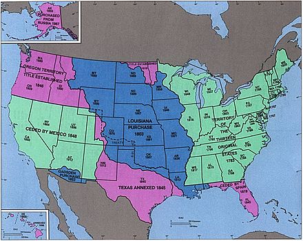
Первое большое расширение страны произошло с покупкой Луизианы в 1803 году, которая удвоила территорию страны, хотя юго-восточная граница с испанской Флоридой была предметом многих споров, пока она и испанские претензии на страну Орегон не были переданы США в 1821 году. Страна Орегон дала Соединенным Штатам выход к Тихому океану , хотя какое-то время он был разделен с Соединенным Королевством . [1] Аннексия Техасской республики в 1845 году привела непосредственно к американо-мексиканской войне , после которой победоносные Соединенные Штаты получили северную половину Мексики.территории России, включая то, что быстро было преобразовано в штат Калифорния . [2] Однако, по мере того, как развитие страны продвигалось на запад, вопрос рабства становился все более важным, с энергичными дебатами о том, допускают ли новые территории рабство и такие события, как Компромисс в Миссури и Кровотечение в Канзасе . Это достигло апогея в 1860 и 1861 годах, когда правительства южных штатов объявили о своем отделении от страны и образовали Конфедеративные Штаты Америки . Американская гражданская война привела к поражению Конфедерации в 1865 году и в конечном итоге реадмиссии государств в Конгрессе Соединенных Штатов. Культурная вера в очевидную судьбу Соединенных Штатов дала мощный импульс экспансии на запад в 19 веке.
Расширение страны за пределы Северной Америки началось в 1856 году с принятием Закона об островах Гуано , в результате чего были заявлены права на многие небольшие и необитаемые, но экономически важные острова в Тихом океане и Карибском море . [3] От большинства этих требований в конечном итоге отказались из-за конкурирующих требований других стран или добычи гуано. Расширение Тихого океана завершилось аннексией Гавайских островов в 1898 году после свержения его правительства пятью годами ранее. Аляска , последнее крупное приобретение в Северной Америке, была куплена у России в 1867 году.
Поддержка независимости Кубы от Испанской империи и падение военного корабля США Мэн привели к испано-американской войне в 1898 году, в которой Соединенные Штаты получили Гуам , Пуэрто-Рико и Филиппины и оккупировали Кубу на несколько лет. . Американское Самоа было приобретено Соединенными Штатами в 1900 году после окончания Второй гражданской войны в Самоа . [4] Соединенные Штаты купили Виргинские острова США у Дании в 1917 году. [5]Гуам и Пуэрто-Рико остаются территориями; Филиппины стали независимыми в 1946 году, после того как были крупным театром Второй мировой войны . После войны многие острова были возложены на США со стороны Организации Объединенных Наций , [6] и в то время как Северные Марианские острова остаются на территории США, Маршалловы острова , Федеративные Штаты Микронезии и Палау вышел из доверия территории в качестве независимых государств. Последним крупным международным изменением было приобретение в 1904 году и возвращение Панаме в 1979 году зоны Панамского канала., некорпоративная территория США, которая контролировала Панамский канал . Окончательная передача формального контроля над регионом Панаме произошла в 1999 году.
Что касается внутренних границ, в то время как территории могут сильно меняться в размерах, однажды образованные государства обычно сохраняют свои первоначальные границы. Только четыре штата - Мэн , Кентукки , Вермонт и Западная Вирджиния - были созданы из земель, на которые претендует другой штат; все остальные были созданы с территорий или непосредственно в результате приобретений. Четыре штата - Луизиана , Миссури , Невада и Пенсильвания - значительно расширились за счет приобретения дополнительных федеральных территорий после их первоначального вступления в Союз. Последнее состояние из смежных Соединенных Штатов, обычно называемый «нижними 48», был принят в 1912 году; пятидесятых и самое последнее состояние был принят в 1959 году.
Легенда для карт [ править ]
- Ключ к цветам карты
- Штаты США (внутренние карты), бесспорная территория США (карты споров)
- Территории США (внутренние карты)
- спорная территория США
- область изменена событием
1776–1784 (американская революция) [ править ]
| Дата | Мероприятие | Изменить карту |
|---|---|---|
| 2 июля 1776 г. и 4 июля 1776 г. | Тринадцать колоний по Королевству Великобритании в Северной Америке все вместе объявили о своей независимости , как Соединенные Штаты Америки, [а] , хотя несколько колоний уже индивидуально объявили независимость: [7]
Столица специально не устанавливалась; в то время Континентальный конгресс собирался в Филадельфии . [24] [25] Многие государства имели нечетко определенные и обследованные границы; они не отмечены на картах как оспариваемые, если только не было активного спора. Границы Северной Каролины были особенно плохо обследованы, ее граница с Южной Каролиной была разбита на несколько частей, ни один из которых не соответствовал духу хартии, [26] [27], а ее граница с Вирджинией была обследована только примерно на полпути вглубь суши. из моря. Несколько северо-восточных штатов имели частично совпадающие претензии: Коннектикут, Массачусетский залив и Нью-Йорк претендовали на землю к западу от принятых ими границ, перекрывая друг друга и со значительными претензиями со стороны Вирджинии. Из этих трех только Коннектикут серьезно отстаивал свои претензии, в то время как Вирджиния, как считается, имела наиболее законные претензии на обширный северо-запад, разделив его на округа и сохранив некоторый ограниченный контроль. На все новые Соединенные Штаты претендовала Великобритания, включая остров Макиас Сил и Норт-Рок , два небольших острова у северо-восточного побережья, которые до сих пор остаются спорными. [28] | Споры: |
| 20 сентября 1776 г. | Графства Нью-Касл, Кент и Сассекс на территории штата Делавэр приняли конституцию , переименовав себя в штат Делавэр . [29] | |
| 28 сентября 1776 г. | Штат Пенсильвания принял конституцию , переименовав себя в Содружество Пенсильвании . [30] | без изменений на карте |
| 20 декабря 1776 г. | Чтобы избежать наступления британских войск на Филадельфию , Континентальный конгресс начал встречу в Балтиморе . [24] [25] | |
| 15 января 1777 г. | Северо-восточный регион Нью-Йорка , известный как Гранты Нью-Гэмпшира , провозгласил независимость как Нью-Коннектикут . [31] [32] [33] | Споры: |
| 4 марта 1777 г. | Континентальный Конгресс вернулся в Филадельфии после того , как угроза ему британских сил закончилась. [24] [25] | |
| 4 июня 1777 г. | Новый Коннектикут был переименован в Вермонт . [33] [31] | Споры: |
| 27 сентября 1777 г. | Континентальный Конгресс бежал Филадельфию после американского поражения в битве при Брендивайне , и кратко встретился в Ланкастере, штат Пенсильвания [24] [25] | |
| 30 сентября 1777 г. | Континентальный Конгресс продолжал двигаться от Филадельфии , поселившись в Йорке, штат Пенсильвания . [24] [25] | |
| 11 июня 1778 г. | Вермонт утверждал, что назывался «Восточный союз», состоящий из нескольких городов в Нью-Гэмпшире, которые 12 марта 1778 года подали прошение о присоединении к Вермонту из-за опасений, что их штат слишком много внимания уделяет своему прибрежному региону. Вермонт так и не получил полного контроля над территорией. [31] [34] [35] [36] [b] | Споры: |
| 21 октября 1778 г. | Из - за давления со стороны Континентального конгресса , Вермонт отменила аннексию Восточного Союза; законодательный орган объявил 12 февраля 1779 года, что Восточный союз должен считаться недействительным с самого начала. [34] [35] [36] | Споры: |
| 2 июля 1779 г. | Континентальный Конгресс вернулся в Филадельфию следующего британского вывода . [24] [25] | |
| 31 августа 1779 г. | Вирджиния отказалась от претензий на юго-запад Пенсильвании . [19] [37] | |
| Март 1780 г. | Северная Каролина и Вирджиния обследовали свою границу дальше вглубь страны. Съемка Вирджинии достигла реки Теннесси , но Северная Каролина дошла только до Камберлендского разрыва , и, поскольку эти две съемки находились примерно в двух милях друг от друга, это создало тонкую территорию, на которую претендовали оба штата. Хотя граница должна была проходить на 36 ° 30 'северной широты , из-за ошибок первых съемок она повернула к северу от нее, достигнув расстояния в семнадцать миль к тому времени, когда она достигла реки Теннесси. [38] [23] | |
| 25 октября 1780 г. | Штат Массачусетс-Бей принял конституцию , переименовав себя в Содружество Массачусетса . | |
| 1 марта 1781 г. | В Статьи конфедерации вступили в силу. [39] | без изменений на карте |
| 4 апреля 1781 г. | Вермонт снова потребовал создания Восточного союза, состоящего из нескольких городов в Нью-Гэмпшире, которые хотели присоединиться к Вермонту; Было интересно больше городов, чем во время первой попытки в 1778 году, хотя, опять же, точная протяженность границ неизвестна. Вермонт так и не получил полного контроля над территорией. [31] [40] [35] [36] [c] | Споры: |
| 16 июня 1781 г. | Вермонт претендовал на то, что называлось «Западным союзом», состоящим из нескольких городов Нью-Йорка , главным образом, чтобы уравновесить попытки Вермонта расширяться на восток. Вермонт так и не получил полного контроля над территорией. [31] [35] [41] [42] Конкретная дата, когда это произошло, неясна; источники предполагают 16 июня, 26 июня и 18 июля. [d] | Споры: |
| 22 февраля 1782 г. | Вермонт отказался от попыток аннексировать Восточный союз из Нью-Гэмпшира и Западный союз из Нью-Йорка . [31] [36] [42] [43] | Споры: |
| 29 октября 1782 г. | Федеральное правительство приняло уступку из Нью - Йорка его западных претензий, которые государство переходящих от 17 февраля 1780 года ; Нью-Йорк объявил своей новой западной границей линией, проведенной к югу от западной оконечности озера Онтарио . В максимальной интерпретации, государство заявило права на территорию, ограниченную озерами Эри , Гурон и Мичиган ; в реки Иллинойс , Миссисипи и Теннесси ; и на север вдоль Аппалачских гор , заканчиваясь на границе с Пенсильванией . [44]Неясно, откуда пришло это заявление; многие источники утверждают, что Нью-Йорк сдал его, но очень немногие уточняют, как он был получен. Один источник заявляет, что это была уступка Шести Наций , которые завоевали большую часть региона. [45] Однако Нью-Йорк никогда серьезно не применял эти требования. Передача включала небольшую оконечность Нью-Йорка к северу от Пенсильвании, которая стала известна как Треугольник Эри . [46] [17] | |
| 30 декабря 1782 г. | Съезд Конфедерации объявил о том , что земля, штат Коннектикут утверждал в северной Пенсильвании была часть Пенсильвании, пытаясь таким образом положить конец Pennamite-Yankee войны . [47] [19] Претензия была продолжением самой северной и самой южной границ Коннектикута на запад, минуя Нью-Джерси и Нью-Йорк , хотя, поскольку северная граница Коннектикута находилась в нескольких милях к северу от северной границы Пенсильвании , небольшой участок Нью-Йорка был также утверждал. Хотя конфликт продолжался в течение некоторого времени, на этом официальные претензии Коннектикута закончились. | |
| 30 июня 1783 г. | Пенсильвания Мятеж 1783 и Пенсильвания реакция правительства на него, вызвали съезд Конфедерации , чтобы оставить Филадельфию для Принстона . [24] | |
| 26 ноября 1783 г. | Конгресс Конфедерации вновь созван в Аннаполисе . [24] | |
| 1 марта 1784 г. | Вирджиния уступила свои претензии к северо-западу от реки Огайо федеральному правительству. [48] [23] Коннектикут продолжал требовать свои западные земли, которые перекрывали уступку Вирджинии. | |
| 12 мая 1784 г. | Великобритания признала независимость Соединенных Штатов, прекратив притязания на страну. [49] [50] [e] Соглашение положило конец Войне за независимость в Америке , хотя военные действия в основном закончились после франко-американской победы в Йорктауне 19 октября 1781 года. Из-за двусмысленности и плохого знания географии договор был неясен в нескольких областях:
Мир Парижа также участвуют договора с Францией и Испанией , с Великобританией уступая Floridas в Испанию . Во время владения Западной Флоридой британцы переместили ее границу на север, и уступка территории Испании, по-видимому, распространялась на всю британскую колонию. Однако британско-американский договор предоставил расширение Западной Флориды Соединенным Штатам, где он расширил Джорджию на юг до 31 ° северной широты , указывая на то, что только первоначальное определение Западной Флориды должно было быть передано Испании. Местные испанские губернаторы также предприняли шаги, чтобы занять форты вдоль реки Миссисипи.с претензиями на все к югу от реки Теннесси ; Неизвестно, насколько официальными или убедительными были эти утверждения, и они не нанесены на карту, поскольку находятся в противоречии с другим испанским заявлением, касающимся границы Западной Флориды. [51] | Споры: |
1784–1803 (Организация территории) [ править ]
| Дата | Мероприятие | Изменить карту |
|---|---|---|
| 23 августа 1784 г. | Регион в центральной части Северной Каролины (современный восточный Теннесси ), недовольный государственным управлением этим районом, провозгласил независимость от штата как штат Франкленд . [f] [52] Правительство Франкленда удерживало некоторый контроль над территорией и подавало петицию о государственности, получая поддержку от семи из девяти требуемых штатов, но продержалось всего несколько лет. [53] [54] | Неофициальное изменение: |
| 1 ноября 1784 г. | Конгресс Конфедерации перемещали в течение короткого промежутка времени в Трентон . [24] | |
| 11 января 1785 г. | Съезд Конфедерации переехал в Нью - Йорк , и будет жить там в течение пяти лет. [24] | |
| 19 апреля 1785 г. | Федеральное правительство приняло цессии от Массачусетса ее крайней западной претензии, которые никогда серьезно не насильственному. [g] [44] [13] | Менять только на бумаге: |
| Июнь 1785 г. | Штат Франкленд был переименован в штат Франклин , чтобы побудить Бенджамина Франклина поддержать штат, но он отказался. [53] | Неофициальное изменение: |
| 13 сентября 1786 г. | Коннектикут уступил свои западные претензии федеральному правительству, за исключением своего Западного резерва , хотя неясно, какой контроль они имели над уступленным регионом. [h] [8] [55] | Менять только на бумаге: |
| 16 декабря 1786 г. | Массачусетс отказался от претензий на западный Нью-Йорк , хотя неясно, удерживал ли Массачусетс когда-либо контроль над регионом, поскольку это требование касалось «почвы, а не суверенитета». [i] [44] [13] Эта земля была позже известна как Покупка Фелпса и Горхэма . | Менять только на бумаге: |
| 13 июля 1787 г. | Территория к северо-западу от реки Огайо , переданная ранее Вирджинией , была организована и широко известна как Северо-Западная территория . [56] [57] | |
| 9 августа 1787 г. | Южная Каролина уступила свои западные претензии федеральному правительству [58] [22], хотя это было результатом неточной географии, и Южная Каролина никогда не претендовала на эту землю. Заявление касалось полосы земли между границей Северной Каролины и истоком реки Тугалу, но, что в то время было неизвестно, река берет свое начало в Северной Каролине. Восточная часть этой уступки будет передана Грузии в 1802 году, несмотря на то, что технически Грузия уже имеет претензии на землю. | Менять только на бумаге: |
| 7 декабря 1787 г. | Делавэр стал первым штатом, ратифицировавшим Конституцию Соединенных Штатов . [59] | без изменений на карте |
| 12 декабря 1787 г. | Пенсильвания стала вторым штатом, ратифицировавшим Конституцию . [60] | без изменений на карте |
| 18 декабря 1787 г. | Нью-Джерси стал третьим штатом, ратифицировавшим Конституцию . [61] | без изменений на карте |
| 2 января 1788 г. | Грузия стала четвертым государством, ратифицировавшим Конституцию . [62] | без изменений на карте |
| 6 января 1788 г. | Коннектикут стал пятым штатом, ратифицировавшим Конституцию . [63] | без изменений на карте |
| 6 февраля 1788 г. | Массачусетс стал шестым штатом, ратифицировавшим Конституцию . [64] | без изменений на карте |
| 28 апреля 1788 г. | Мэриленд стал седьмым штатом, ратифицировавшим Конституцию . [65] | без изменений на карте |
| 23 мая 1788 г. | Южная Каролина стала восьмым штатом, ратифицировавшим Конституцию . [66] | без изменений на карте |
| 21 июня 1788 г. | Нью-Гэмпшир стал девятым штатом, ратифицировавшим Конституцию ; [67] с этого момента Конституция стала действующим руководящим документом тех девяти штатов, которые ратифицировали ее (согласно статье VII ). | без изменений на карте |
| 25 июня 1788 г. | Вирджиния стала десятым штатом, ратифицировавшим Конституцию . [68] | без изменений на карте |
| 26 июля 1788 г. | Нью-Йорк стал одиннадцатым штатом, ратифицировавшим Конституцию . [69] | без изменений на карте |
| Февраль 1789 г. | Джон Севьер , губернатор штата Франклин , присягнул на верность Северной Каролине , фактически положив конец заявленной независимости Франклина. [53] [70] | Неофициальное изменение: |
| 7 августа 1789 г. | Северо - Западный край был преобразован в соответствии с Конституцией . [71] | без изменений на карте |
| 21 ноября 1789 г. | Северная Каролина стала двенадцатым штатом, ратифицировавшим Конституцию . [72] | без изменений на карте |
| 2 апреля 1790 г. | Северная Каролина уступила свою западную половину федеральному правительству. [j] [73] [54] | |
| 26 мая 1790 г. | Земля, недавно переданная Северной Каролине, была организована как территория к югу от реки Огайо, широко известная как Юго-Западная территория . [54] [74] | |
| 29 мая 1790 г. | Род-Айленд стал тринадцатым штатом, ратифицировавшим Конституцию . [75] | без изменений на карте |
| 6 декабря 1790 г. | Согласно Закону о резидентстве , Конгресс Соединенных Штатов переехал в Филадельфию на десять лет, пока не был построен и готов федеральный округ . [24] [25] [76] | |
| 4 марта 1791 г. | Вермонт , который считался частью Нью-Йорка, несмотря на то, что с 1777 года действовал независимо , был признан четырнадцатым штатом. [k] [31] [77] | Споры: |
| 30 марта 1791 г. | Округ Колумбия , в федеральном округе планируется разместить федеральное правительство к 1800 году , был сформирован из земли , удержанные по Мэриленде и Вирджинии , [78] , [79] , состоящий из 100 квадратных миль алмаз, с его южной оконечности в Jones Поинт , расставив река Потомак. Однако этого названия ему пока не давали, а называли просто федеральным округом. В сентябре 1791 года уполномоченные, отвечающие за планирование города, назвали его «территорией Колумбии», и различные законы относились к округу Колумбия, но иногда неофициально. Похоже, что этот район официально не назывался «Округ Колумбия», по крайней мере, до органического акта 1871 года . [80] Поскольку название «Колумбия» использовалось с самого начала и, по крайней мере, неофициально правительством, начиная с этой даты на карте будет использоваться «Округ Колумбия». | |
| 3 марта 1792 г. | Пенсильвания купила треугольник Эри у федерального правительства. [19] | |
| 1 июня 1792 г. | Западная половина Вирджинии , которую штат согласился в 1789 году уступить федеральному правительству [81], была признана пятнадцатым штатом Кентукки . [l] [83] [82] | |
| 12 июня 1792 г. | Штат Делавэр принял новую конституцию , переименовав себя в штат Делавэр . [84] | без изменений на карте |
| 3 августа 1795 г. | Представители Соединенных Штатов и Западной Конфедерации подписывают Гринвильский договор , положивший конец Северо-Западной индийской войне и уступивший большую часть современного штата Огайо контролю Соединенных Штатов. [85] | без изменений на карте |
| 29 февраля 1796 г. | Великобритания согласилась оставить несколько фортов на северо-западе, которые она все еще занимала, включая Детройт . Договор Джея также предусматривал создание комиссий для определения границы между северо-западной точкой озера Вудс и истоком реки Миссисипи , а также какую реку считать рекой Санта-Крус . [86] | без изменений на карте |
| 25 апреля 1796 г. | Северная половина Западной Флориды была передана по Испании , решение спора в регионе. [87] [88] | Споры: |
| 1 июня 1796 г. | Southwest территория была принята в качестве шестнадцатого государства, Теннесси . [54] [89] | |
| 7 апреля 1798 г. | Из-за мошенничества с землей в Yazoo закон уполномочил президента Джона Адамса назначить уполномоченных для переговоров с Грузией об уступке ее западной земли. В соответствии с этим законом территория Миссисипи была создана из юго-западной части Джорджии в регионе, который недавно уступила Западная Флорида , при этом Грузия все еще имела права на эту территорию. [90] [91] | |
| 25 октября 1798 г. | Комиссары согласились с источником реки Санта-Крус , установив нижнюю часть границы между Массачусетсом и Великобританией и, таким образом, где берет начало восточная линия север-юг. [92] | Споры: |
| 9 июня 1800 г. | Коннектикут передал свой Западный заповедник федеральному правительству, которое отнесло его к Северо-Западной территории . [93] Закон об этом был принят Конгрессом 28 апреля 1800 года, и Коннектикут одобрил его в этот день. [94] | |
| 4 июля 1800 г. | Территория Индианы была организована из западной части Северо-Западной территории . [м] [96] [95] | |
| 17 ноября 1800 г. | Конгресс США переехал в Вашингтон в округе Колумбия , в настоящее время построен и готов стать столицей. [24] Это было за две недели до 1 декабря, установленного Законом о проживании ; Президент Джон Адамс призвал Конгресс действовать как можно раньше в надежде получить достаточно голосов южан для переизбрания, но это не удалось. [97] | |
| 1 января 1801 г. | Королевство Великобритании объединились с Королевством Ирландии , переименовав себя Соединенного Королевства . [98] | |
| 27 февраля 1801 г. | Округ Колумбия был организован . [79] [99] | без изменений на карте |
| 26 апреля 1802 г. | Грузия уступила свою западную часть, известную как земли Язу , федеральному правительству. [n] В то же время федеральное правительство уступило Джорджии восточную часть земли, ранее уступленную Южной Каролиной , хотя на самом деле Джорджия технически уже имела право собственности на землю, поскольку описание более ранней уступки основывалось на ошибочной понимание географии. [11] | |
| 1 марта 1803 г. | Южная половина Северо-Западной Территории , вместе с тонкой полосой Территории Индиана , была признана семнадцатым штатом Огайо . Остальная часть Северо-Западной территории была передана Территории Индианы. [100] [56] Западная граница проходила на севере от устья реки Грейт Майами ; Федеральное определение северной границы было линией, проведенной к востоку от южной оконечности озера Мичиган , тогда как в Конституции штата Огайо говорилось, что линия должна проходить от южной оконечности озера Мичиган до самого северного мыса залива Моми , по сути, западной оконечности озера. Озеро Эри. Путаница, вызванная этими разными описаниями границ штата, в сочетании с неточным знанием географии, поскольку никто в то время не знал, насколько далеко на юг простирается озеро Мичиган, приведет к конфликту из-за Толедо . | |
| 3 ноября 1803 г. | Граница между Теннесси и Вирджинией была повторно исследована и установлена, положив конец спору по поводу этой части границы. Граница между Кентукки и Теннесси , несмотря на результаты первоначального исследования, оставалась неопределенной. [38] [101] |
1803–1818 (покупка Луизианы) [ править ]
| Дата | Мероприятие | Изменить карту |
|---|---|---|
| 20 декабря 1803 г. | Соединенные Штаты купили Луизиану у Франции . Это дата официального оборота в Новом Орлеане ; покупка была завершена 30 апреля 1803 года. [102] Передача будет признана в Сент-Луисе в Верхней Луизиане 10 марта 1804 года, известном как День трех флагов . Приобретение расширило Соединенные Штаты до всего бассейна реки Миссисипи , [o] но степень того, что составляло Луизиану на юге, оспаривалась с Испанией : Соединенные Штаты утверждали, что покупка включала часть Западной Флориды к западу от реки Пердидо. , в то время как Испания утверждала, что он заканчивается на западной границе Западной Флориды; [р] [103] и юго - западная граница с Новой Испанией были спорный , так как Соединенные Штаты утверждали реку Sabine в качестве границы, но Испа- это была река Calcasieu и другие. [102] | Споры: |
| 1804 г. | « Саутвик Джог » был переведен из Коннектикута в Массачусетс , чтобы положить конец давним разногласиям по поводу границы между двумя штатами. [13] | |
| 27 марта 1804 г. | Земля между Теннесси и территорией Миссисипи, ранее уступленная Джорджией, была передана территории Миссисипи. [91] [104] | |
| 1 октября 1804 г. | Территория Орлеана была организована из Луизианы Закупки к югу от 33 ° северной широты , а остальные были обозначены как Округ Луизианы и находились под юрисдикцией Территории Индиана . [105] [106] | |
| 30 июня 1805 г. | Территория Мичиган была организована из Территории Индиана , к северу от линии к востоку от южной оконечности озера Мичиган и к востоку от линии к северу от северной оконечности озера. [107] [108] Юго-восточная часть границы технически противоречила определению штата Огайо , который претендовал на полосу Толедо к северу от этой линии; однако точное местонахождение озера Мичиган еще не было известно. | |
| 4 июля 1805 г. | Округ Луизианы был организован в Луизиане территории . [106] [109] | |
| 1 марта 1809 г. | Территория Иллинойс была организована из западной половины территории Индианы . [q] [111] [110] | |
| 26 сентября 1810 г. | Республика Западной Флориды провозгласила независимость от Испании , утверждая , что площадь Западной Флориды к западу от реки Пердиды . Он сохранил некоторый контроль над своей территорией. [112] | Споры: |
| 10 декабря 1810 г. | Вооруженные силы под командованием Уильяма К.К. Клэйборна овладели частью Западной Флориды к западу от реки Чжуцзян после того, как 27 октября 1810 года президент Джеймс Мэдисон объявил об этом. Соединенные Штаты считали этот регион частью Покупки Луизианы , включая территорию, которая восстала против испанской Флориды и образовала Республику Западная Флорида . В прокламации Мэдисона говорилось, что он должен быть «взят как часть» территории Орлеана . [103] [102] [113] Земля к западу от Мобил-Бэй до Жемчужной реки была оккупирована и аннексирована де-фактовоенными в 1811 году. [114] : 2a ( карта ) | Споры: |
| 30 апреля 1812 г. | Большая часть территории Орлеан была признана восемнадцатым штатом Луизиана . [r] [106] [115] Юго-восточная часть, по-видимому, стала неорганизованной территорией, поскольку в течение короткого времени у нее не было определения. | |
| 14 мая 1812 г. | Заявленная часть Западной Флориды к востоку от Жемчужной реки была отнесена к территории Миссисипи , хотя территория вокруг Мобил-Бэй оставалась под контролем испанской Флориды . [91] [116] Соединенные Штаты военными оккупировали Мобил и его окрестности вплоть до реки Пердидо в апреле 1813 года. | |
| 4 июня 1812 г. | Так как его название теперь было совместно со штатом Луизиана , территория Луизианы была переименована в Территорию Миссури . [117] [118] | |
| 4 августа 1812 г. | Оставшаяся заявленная часть Западной Флориды , к западу от Жемчужной реки , была присоединена к Луизиане после того, как этот штат одобрил закон, принятый Конгрессом 14 апреля 1812 года. [119] [120] | |
| 16 августа 1812 г. | Во время войны 1812 года гарнизон в форте Детройт сдался , в результате чего Великобритания оккупировала Детройт , столицу и населенный пункт территории Мичиган . [121] | Споры: |
| 29 сентября 1813 г. | Форт Детройт был отброшен американскими войсками после битвы на озере Эри , восстановив контроль над территорией Мичиган . [121] [122] | Споры: |
| 24 августа 1814 г. | Британские войска захватывают и сжигают Вашингтон , но на следующий день вынуждены отступить. Функции столицы были приостановлены лишь на мгновение, хотя президент Джеймс Мэдисон укрылся в Бруквилле, штат Мэриленд . [123] | без изменений на карте |
| 11 декабря 1816 г. | Южная часть территории Индиана , наряду с небольшими частями территорий Иллинойс и Мичиган , была признана девятнадцатым штатом Индиана . [s] Остальная часть территории Индиана через озеро Мичиган стала неорганизованной территорией. [95] [124] | |
| 3 марта 1817 г. | Территория Алабама была организована из восточной части территории Миссисипи . [t] [126] [125] | |
| 10 декабря 1817 г. | Территория Миссисипи была признана двадцатым штатом Миссисипи . [91] [127] | |
| 6 февраля 1818 г. | Территория Алабамы создала округ Тускалуза с описанием, которое случайно перекликалось с Миссисипи . Граница графства описывалась как «строго западный курс к реке Томбек, а оттуда вверх к порту хлопка-джина». [128] В то время неизвестно, откуда река Томбигби и порт для хлопкового джина происходили из Миссисипи. | Менять только на бумаге: |
| 30 июня 1818 г. | В соответствии с условиями Договора Гента концовки войны 1812 года Великобритания вернулась Лосиный остров в штате Массачусетс , и Соединенные Штаты вернулись Campobello остров , остров оленей и Гранд Manan остров в Соединенное Королевство, все из которых были захвачены из другая сторона во время войны. [129] | без изменений на карте |
| 3 декабря 1818 г. | Половина территории Иллинойс к югу от 42 ° 30 'северной широты была признана двадцать первым штатом Иллинойс . Остальная часть территории вместе с неорганизованной территорией, которая недавно была частью территории Индиана , была передана территории Мичиган . [110] [130] |
1819–1845 (Северо-западное расширение) [ править ]
| Дата | Мероприятие | Изменить карту |
|---|---|---|
| 30 января 1819 г. | Договор 1818 года вступил в силу, установив 49 ° на севере , как границы с Соединенным Королевством к западу от озера Вудса , а также о создании Oregon Страны в общей области с Соединенным Королевством. [1] [131] [132] Страна Орегон не имела определенной северной границы, но можно предположить, что она не сильно вторгалась в земли, удерживаемые русскими ; на этой карте для простоты используется установленная позднее линия на 54 ° 40 ′ северной широты . | Северо-запад Северной Америки: |
| 4 июля 1819 г. | Территория Арканзоу была организована из южной части территории Миссури . [u] [133] [134] | |
| 14 декабря 1819 г. | Территория Алабама была признана двадцать вторым штатом Алабама . [125] [135] Акт о государственности предусматривал обследование южной части границы с Миссисипи , которая должна была проходить с севера на юг, для корректировки, если будет обнаружено, что она посягает на установленные округа Миссисипи; позже было обнаружено, что это так. | |
| 15 марта 1820 г. | В рамках Компромисс Миссури , то округ штата Мэн , северной и отдельной части штата Массачусетс , был принят в качестве двадцать третьего государства, Мэн . [136] [137] | |
| 21 апреля 1820 г. | Это самая ранняя известная дата, когда название « Территория Арканзас » официально используется вместо «Территория Арканзас». [138] | |
| 12 мая 1820 г. | Граница между Кентукки и Теннесси была установлена. Чтобы компенсировать тот факт, что граница между Камберлендским ущельем и рекой Теннесси повернула на север на целых 17 миль от 36 ° 30 ′ северной широты, было проведено новое исследование, начиная с этой широты на реке Миссисипи и двигаясь на восток до Теннесси. Река, следовательно, эта последняя граница будет соответствовать первоначальному идеалу. [38] | |
| 19 июля 1820 г. | Наложение продольной южной границы между Алабамой и Миссисипи было решено в соответствии с законом, признающим Алабаму штатом, поскольку временная граница вторгалась в Миссисипи. [125] [139] В результате обследования конечная остановка южной границы была перемещена примерно на 3,8 мили к востоку, что изменило границу до тогдашнего северо-западного угла округа Вашингтон в Алабаме. Дата, когда это произошло, неясна; имеющиеся источники сообщают либо неопубликованный отчет от 29 мая 1820 г., либо о завершении демаркации новой линии 19 июля 1820 г. | Менять только на бумаге: |
| 19 декабря 1820 г. | Алабама пересмотрела границы некоторых графств, положив конец ошибочному перекрытию Миссисипи, созданному 6 февраля 1818 года. [140] | Менять только на бумаге: |
| 22 февраля 1821 г. | Договор Адамс-Onís с Испании вступил в силу. [103] Многие изменения включали:
| Споры: |
| 10 июля 1821 г. | Восточная Флорида была официально передана Соединенным Штатам Испанией . [141] | |
| 17 июля 1821 г. | Западная Флорида была официально передана Соединенным Штатам Испанией . [141] | |
| 10 августа 1821 г. | Юго-восточная часть территории Миссури была признана двадцать четвертым штатом Миссури , а остальная часть стала неорганизованной территорией. [w] [118] [142] | |
| 30 марта 1822 г. | Бывшие Восточная Флорида и Западная Флорида были организованы как Территория Флориды . [143] [144] | |
| 26 мая 1824 г. | Половина территории Арканзас к западу от линии к югу от точки в 40 милях к западу от западной границы Миссури была возвращена на неорганизованную территорию. [134] [145] | |
| 12 января 1825 г. | Договор с Российской империей создана 54 ° 40 'северной широты как северная граница Страны Орегона для американских целей; отдельный договор установил ту же границу между Россией и Соединенным Королевством . [146] Поскольку это была, вероятно, фактическая граница в любом случае, регион уже нанесен на карту этой линией. | без изменений на карте |
| 6 мая 1828 г. | Договор с чероки переместил западную границу территории Арканзас , вернув часть ее неорганизованной территории. [x] [134] [148] | |
| 20 января 1831 г. | Король Нидерландов Вильгельм I , которого в соответствии с Гентским договором попросили разрешить спорную границу между Мэном и Соединенным Королевством , вынес свое решение: поскольку согласовать договор с данными картами было слишком сложно, он провел линию компромисса. Британское правительство приняло его, но Мэн возразил, и 19 января 1832 года американское правительство отклонило его. [149] | без изменений на карте |
| 9 июля 1832 г. | Регион Нью-Гэмпшира к северу от озер Коннектикут , который оспаривался Соединенным Королевством , провозгласил независимость как Республика Индийского потока . [150] Несмотря на крошечный размер, он, похоже, сохранил некоторый контроль над своей территорией. | Споры: |
| 28 июня 1834 г. | Мичиган край приобрел большой участок земли с неорганизованной территорией, простираясь на запад к реке Миссури и Уайт - Ривер Земли . [108] [151] | |
| 5 августа 1835 г. | Республика Индийского потока признала юрисдикцию Нью - Гемпшир , завершив таким образом свою заявленную независимость. Приведена дата сообщения, отправленного британским властям; [152] другие источники отмечают резолюцию, принятую гражданами Индийского потока 2 апреля 1836 года. [150] | Споры: |
| 15 июня 1836 г. | Территория Арканзаса была признана двадцать пятым штатом Арканзас . [134] [153] | |
| 3 июля 1836 г. | Территория Висконсин была организована из западной части территории Мичиган . [y] [154] [155] Два больших полуострова между Великими озерами остались на территории Мичигана; верхний полуостров был включен в обмен на территории отказавшись от своей претензии на Толедо Газа . Территория изначально отвергла этот план, но примет его 14 декабря. | |
| 14 декабря 1836 г. | Территория Мичигана согласилась отказаться от притязаний на Толедо-Стрип , положив конец спору с Огайо . [156] | |
| 26 января 1837 г. | Территория Мичигана была признана двадцать шестым штатом Мичиган . [108] [157] | |
| 28 марта 1837 г. | Платт Покупка передавался земли от неорганизованной территории на северо - запад Миссури , расширяя свой северную границу на запад к реке Миссури . [118] [158] | |
| 3 июля 1838 г. | Территория Айова была организована на территории Висконсин к западу от реки Миссисипи . [159] [160] | |
| 11 февраля 1839 г. | Миссури потребовал территорию к северу от границы с территорией Айовы , положив начало долгому спору, известному как Медовая война . [161] | |
| 21 мая 1840 г. | Исследования, проведенные вдоль границы с Техасом, показали, что территория, на которую претендует Арканзас для округа Миллер, принадлежит Техасу. [162] | |
| 10 ноября 1842 г. | Договор Вебстера-Эшбертона определил границу с Соединенным Королевством к востоку от Скалистых гор . [163] [164] В одном источнике также упоминается, что это очень незначительно изменяет морскую границу между Мичиганом и территорией Висконсин. [165] Договор урегулировали споры по поводу северных границ штата Мэн и Нью - Гемпшир , [г] северо - восточная граница штата Висконсин территории , [аа] и остров Сахарная с Мичигане . Граница между Нью-Йорком и Вермонтом, с одной стороны, и Соединенным Королевством, с другой, была уточнена договором. В 1816 году началось строительство безымянного форта, получившего прозвище « Форт Бландер » на полуострове в озере Шамплейн, который, находясь к югу от обследованной границы, был обнаружен к северу от 45 ° северной широты , что было границей, установленной Парижским договором и таким образом на британской территории. Следовательно, строительство форта было прекращено. В соглашении Вебстера-Эшбертона уточнялось, что участок границы должен проходить по обследуемой линии, а не по точной параллели, таким образом перемещая территорию форта в Соединенные Штаты и новый форт, Форт Монтгомери., будет построен на месте в 1844 году. [167] Поскольку предыдущая линия была исследована, хотя она и не соответствовала определению, она была признана законной границей. | Споры: |
| 5 июля 1843 г. | Местные поселенцы создали временное правительство для Орегонских . Хотя он и не был официальным, он сохранял некоторую юрисдикцию в этом районе. [168] | Неофициальное изменение: Северо-Западная Северная Америка: |
| 3 марта 1845 г. | Территория Флориды была признана двадцать седьмым штатом Флорида . [144] [169] |
1845–1860 (расширение на юго-запад) [ править ]
| Дата | Мероприятие | Изменить карту |
|---|---|---|
| 29 декабря 1845 г. | Республика Техас был присоединен и принят в двадцать восьмом состоянии, Техас , расширяя США на юго - запад к Рио - Гранде . [170] [171] Весь Техас был захвачен Мексикой . Хотя многие источники утверждают, что Мексика признала независимость восточной части Техаса, эти договоры были отклонены мексиканским правительством. Техас формально передал суверенитет Соединенным Штатам на церемонии 19 февраля 1846 года. [172] Аннексия привела к началу американо-мексиканской войны несколько месяцев спустя. [172] | Споры: |
| 15 июня 1846 г. | Орегонский договор установил 49 ° к северо западу от озера Вудса в континентальных границах (так она не включает остров Ванкувер ) с землями , находящихся в Соединенном Королевстве . Разделение Страны Орегон закончилось, и часть Соединенных Штатов стала неорганизованной территорией. [173] В договоре было неясно, какой пролив должен быть границей между островом Ванкувер и континентом, что вызвало спор о праве собственности на острова Сан-Хуан . [174] Это указано «через середину указанного канала и проливов Фука к Тихому океану». | Северо-запад Северной Америки: Споры: |
| 22 сентября 1846 г. | После захвата 18 августа 1846 года в Санта - Фе , столицы мексиканской территории Санта - Фе - де - Nuevo México , [175] свод законов , известный как Кирни кодекс был создан для этой области. [176] [177] Область частично совпадала с заявлением Техаса , хотя Техас практически не контролировал территорию за пределами своей восточной части. | Неофициальное изменение: |
| 28 декабря 1846 г. | Часть территории Айовы к югу от 43 ° 30 'к северу и востоку от реки Биг Сиу была признана двадцать девятым штатом Айова . Остальная часть стала неорганизованной территорией. [160] [178] | |
| 13 марта 1847 г. | Округ Колумбия retroceded Alexandria County обратно в Вирджинии . [79] Конгресс принял закон 9 июля 1846 г. [179] жителей округа Александрия были объявлены президентом согласившимися на него 7 сентября 1846 г. [180], и в этот день Вирджиния вступила во владение землей. [181] | |
| 29 мая 1848 г. | Южная большая часть территории Висконсин была признана тридцатым штатом Висконсин . [ab] Остальная часть стала неорганизованной территорией. [155] [182] Однако оставшиеся граждане решили продолжить гражданское правительство и даже избрали делегата в Палату представителей Соединенных Штатов, который будет заседать 15 января 1849 года, что, по сути, сделало этот регион де-факто факто продолжение территории Висконсин. [183] | |
| 4 июля 1848 г. | Договор Гуадалупе Идальго закончилась американо-мексиканской войны и уступила большой участок земли из Мексики , состоящий из его территории Альта Калифорния и Санта - Фе - де - Nuevo México , и его претензии на Техас . [ac] [185] Из-за разногласий по поводу южной границы Санта-Фе-де-Нуэво-Мексика начался пограничный спор. [184] | Споры: |
| 14 августа 1848 г. | Территория Орегона была организована из неорганизованной территории, которая ранее была частью Страны Орегон . [186] [187] | |
| 13 февраля 1849 г. | Пограничный спор между Айова и Миссури известный как Honey войны был решен в Верховном суде Соединенных Штатов . Получившейся границей стала линия Салливана , существовавшая до спора, примерно разделявшая два требования. [188] | |
| 3 марта 1849 г. | Территория Миннесота была организована из региона, который де-факто действовал как территория Висконсин , и неорганизованной территории к востоку от рек Миссури и Белая Земля . [189] [166] | |
| 12 марта 1849 г. | Местное правительство сформировало штат Дезерет и потребовало огромную часть юго-запада, включая большую часть мексиканской уступки . Хотя он ходатайствовал о приеме в Соединенные Штаты, это предложение было отклонено, и в 1850 году вместо него была образована территория Юта . [190] Заявленная территория немного перекрывала заявленную территорию Техаса , а также часть территории Орегона . | Неофициальное изменение: |
| 24 ноября 1849 г. | Техас с согласия Конгресса Соединенных Штатов [191] расширил свою границу с Луизианой от западного берега реки Сабин до середины реки. [191] [192] [193] [194] | без изменений на карте |
| 9 сентября 1850 г. | Западная часть Мексиканской Цессии была признана тридцать первым штатом Калифорния . [ad] [2] [195] Часть оставшейся части к северу от 37 ° к северу и западу от вершины Скалистых гор была организована как территория Юта . [196] [197] Часть территории Юта перекрывалась с частью Техаса, которая должна была быть куплена 13 декабря 1850 года, но закон, разрешающий покупку, был принят в этот день, поэтому границы территории Юты предполагали, что покупка будет осуществлена. . | |
| 9 декабря 1850 г. | Соединенное Королевство уступило менее одного акра подводной скалы известный как Подкова Риф в озере Эри недалеко от Буффало, штат Нью - Йорк на маяк. Он был окружен британскими водами, создавая форму анклава. [198] | |
| 13 декабря 1850 г. | Федеральное правительство купило западные претензии Техаса . [ae] [171] Территория Нью-Мексико была организована из части этой земли к востоку от Рио-Гранде , вместе с оставшейся неорганизованной территорией из Мексиканской Сессии . [af] [200] [199] Территория Нью-Мексико включала всю территорию, которая регулировалась в соответствии с Кодексом Кирни . | |
| 5 апреля 1851 г. | Дезрает самороспуск, его функция и территория в значительной степени будучи вытеснены Ютом территорией . [201] | Неофициальное изменение: |
| 2 марта 1853 г. | Территория Вашингтона была организована из половины территории Орегона к северу от 46 ° северной широты и реки Колумбия . [202] [203] | |
| 30 мая 1854 г. | Территория Канзаса была организована из неорганизованной территории к северу от 37 ° северной широты , а территория Небраска была организована к северу от 40 ° северной широты . [204] [205] [206] Большая часть оставшейся неорганизованной территории к востоку от 100 ° з.д. стала известна как Индийская территория , обозначенная как место переселения индейских племен. Небольшая полоса между Техасским Панхандлом и территорией Канзас оказалась невостребованной из-за падения к югу от границы территории Канзаса, но к северу от 36 ° 30 ′ северной широты, установленной в Компромиссе Миссури как северный предел рабства, и, таким образом, Техас не мог иметь его. Это стало известно как Государственный земельный участок , или иногда «Ничейная земля». [207] | |
| 30 июня 1854 г. | Соединенные Штаты приобрели в Мексике большой участок, известный как покупка Гадсдена , поскольку он предлагал гораздо лучший маршрут для южной трансконтинентальной железной дороги. [ag] [208] [209] Это разрешило пограничный спор, поскольку спорная земля была включена в покупку. [184] | Споры: |
| 4 августа 1854 г. | Недавно полученная покупка Гадсдена была передана территории Нью-Мексико . [199] [210] | |
| 11 января 1855 г. | Из-за недоступности для остальной части штата Бостонский уголок был переведен из Массачусетса в Нью-Йорк . [211] [212] [213] | |
| 6 марта 1855 г. | Верховный суд вынес решение в пользу Флориды в пограничном споре с Джорджией , установив линию государственной границы по линии МакНила . [214] | без изменений на карте |
| 28 октября 1856 г. | Остров Бейкер и Джарвис были заявлены в соответствии с Законом Guano островов . [3] | Тихий океан: |
| 11 мая 1858 г. | Восточная половина территории Миннесота была признана тридцать вторым штатом Миннесота . [ах] Остальная часть стала неорганизованной территорией. [166] [215] | |
| 31 августа 1858 г. | Остров Навасса был заявлен в соответствии с Законом об островах Гуано . [3] | Карибское море: |
| 3 декабря 1858 г. | Остров Хауленд был заявлен в соответствии с Законом об островах Гуано . [3] | Тихий океан: |
| 14 февраля 1859 г. | Западная половина территории Орегона была признана тридцать третьим штатом Орегон . [ai] Остаток был передан на территорию Вашингтона . [187] [216] | |
| 6 июля 1859 г. | Группа геодезистов создала «Смещение Миддлтона», небольшую выемку на границе между Кентукки и Теннесси . Точно неизвестно, почему это было сделано, хотя, по одной из версий, местный землевладелец хотел получить свою собственность в Теннесси. [217] [218] | |
| 6 сентября 1859 г. | Джонстон Утверждалось под закон о гуано , [3] , хотя он был востребован на Гавайях в 1858 году [219] | Тихий океан: |
| 7 ноября 1859 г. | Было создано местное правительство, охватившее части территорий Канзаса , Небраски , Нью-Мексико , Юты и Вашингтона с названием Территория Джефферсона . [aj] Хотя федеральное правительство никогда не признавало его, оно в целом контролировало территорию до тех пор, пока не была создана территория Колорадо , которая приняла большинство своих законов. [220] | Неофициальное изменение: |
| 27 декабря 1859 г. | Эндерберите Остров , Остров МакКина , остров Феникс , и Старбак были заявлены в соответствии с Законом Guano островов . [3] | Тихий океан: |
| 29 декабря 1859 г. | Остров Рождества и Молден были заявлены в соответствии с Законом Guano островов . [3] | Тихий океан: |
| 8 февраля 1860 г. | Техас создал графство Грир , претендующее на часть Индийской территории, на основании другого понимания от федерального правительства, разветвление Красной реки являлось границей между ними. [221] Атаф , Birnie Island , Бутаритари , Остров Каролина , Остров Фэннинг , остров Флинт , остров Гарднер , остров Кантон , Риф Кингмно , Манихики , Маракеи , Nukunono , атолл Пальмиры , Penrhyn , Пукапук , Ракаханг , Суэйнс , остров Сидней , остров Восток , и Все острова Вашингтон были заявлены в соответствии с Законом об островах Гуано .[3] Многие дополнительные острова были перечислены как связанные в этот день, но, судя по координатам, они были либо фантомами, либо дубликатами. Кроме того,был заявлен остров Сары-Энн , который, возможно, существовал и будет обнаружен еще в 1917 году, но с тех пор исчез. [222] | Тихий океан: |
1860–1865 (Гражданская война) [ править ]
| Дата | Мероприятие | Изменить карту |
|---|---|---|
| 20 декабря 1860 г. | В ответ на выборы от Авраама Линкольна , Южная Каролина объявила о своем выходе из Союза, выход из Конгресса США. [223] | Споры: |
| 9 января 1861 г. | Миссисипи объявила о выходе из Союза, о выходе из Конгресса. [223] | Споры: |
| 10 января 1861 г. | Флорида объявила о выходе из Союза, о выходе из Конгресса. [223] | Споры: |
| 11 января 1861 г. | Алабама объявила о выходе из Союза, о выходе из Конгресса. [223] | Споры: |
| 19 января 1861 г. | Грузия объявила о выходе из Союза, о выходе из Конгресса. [223] | Споры: |
| 26 января 1861 г. | Луизиана объявила о выходе из Союза, о выходе из Конгресса. [223] Однако 1-й и 2-й избирательные округа вокруг Нового Орлеана сохранили представительство в Конгрессе. | Споры: |
| 29 января 1861 г. | Большая часть территории Канзас к востоку от 25 ° западнее Вашингтона была признана тридцать четвертым штатом Канзас . Остальная часть стала неорганизованной территорией. [205] [224] | |
| 8 февраля 1861 г. | Конфедеративные Штаты Америки была образована представители отделившихся штатов Алабама , Джорджия , Флорида , Луизиана , Миссисипи и Южная Каролина . [225] | Споры: |
| 28 февраля 1861 г. | Территория Колорадо была организована из частей Nebraska территории , Нью - Мексико территории , и Ют территории , наряду с неорганизованной территорией. [ak] [227] [226] | |
| 2 марта 1861 г. | Техас объявил о своем выходе из Союза и был принят в Федеральных Штатах , [223] [228] выходит из Конгресса. Территория Дакота была организована на территории Небраски и неорганизованной территории к северу от нее. [al] Западная граница территории Небраска была перемещена на 27 ° к западу от Вашингтона , получив небольшие участки территории Юта и Вашингтон . [206] [229] [230] Территория Невада была организована из Территории Юта к западу от 39 ° западнее Вашингтона . [231] [232] | Споры: |
| 28 марта 1861 г. | Представители южной половины территории Нью-Мексико провозгласили независимую территорию Аризоны к югу от 34 ° северной широты . [233] | Споры: |
| 12 апреля 1861 г. | Битва Форт Самтер в Южной Каролине начинается американской гражданской войны . | Споры: |
| 17 апреля 1861 г. | После битвы Форт Самтер и президент Авраам Линкольн «s призыв к войскам , чтобы ответить , Вирджиния объявили о своем выходе из Союза, выхода из Конгресса. [223] Однако 1-й (вдоль восточного побережья ), 7-й (недалеко от Вашингтона, округ Колумбия ), 10-й , 11-й и 12-й (на северо-западе штата) округа по выборам Конгресса сохранили представительство в Конгрессе. | Споры: |
| 6 мая 1861 г. | Арканзас объявил о своем выходе из Союза, о выходе из Конгресса. [223] | Споры: |
| 7 мая 1861 г. | Вирджиния была принята в Конфедеративные Штаты . [234] | Споры: |
| 16 мая 1861 г. | Кентукки объявил себя нейтральным во время Гражданской войны в США . | без изменений на карте |
| 20 мая 1861 г. | Арканзас был принят в состав Конфедеративных Штатов . [235] Северная Каролина объявила о выходе из Союза, о выходе из Конгресса. [223] | Споры: |
| 21 мая 1861 г. | Северная Каролина была принята в состав Конфедеративных Штатов . Закон, признающий государство, требовал президентской прокламации, прежде чем он должен был вступить в силу [236], что, по словам источников, имело место в этот день; [237] Единственным найденным первоисточником является заявление Джефферсона Дэвиса от 20 июля о том, что прокламация была сделана. [238] | Споры: |
| 6 июня 1861 г. | Роберт Уильямсон Стил , губернатор Территории Джефферсона , объявил территорию распущенной и передал правительство первому губернатору Территории Колорадо . [220] | Неофициальное изменение: |
| 8 июня 1861 г. | Теннесси объявил о своем выходе из Союза, о выходе из Конгресса. [223] Однако 2-й , 3-й и 4-й избирательные округа в центральной части штата сохранили представительство в Конгрессе. | Споры: |
| 25 июня 1861 г. | Федеральное правительство признало Восстановленное правительство Вирджинии в Уилинге в качестве законного правительства Вирджинии . [239] | |
| 2 июля 1861 г. | Теннесси был принят в состав Конфедеративных Штатов . [240] | Споры: |
| 1 августа 1861 г. | После Федеральных победы в первой битве Mesilla , Arizona Территория была объявлена в рамках Федеральных государств . [241] | Споры: |
| 13 сентября 1861 г. | После оккупации Конфедерацией Колумбуса , Кентукки , 3 сентября 1861 года штат отказался от нейтралитета и присоединился к правительству Союза. [242] | без изменений на карте |
| 31 октября 1861 г. | Отколовшееся правительство в Неошо, штат Миссури , объявило об отделении штата от Соединенных Штатов. [223] | Споры: |
| 20 ноября 1861 г. | Съезд в Расселвилле, Кентукки , объявил о формировании расколотого правительства в Боулинг-Грин и отделении Кентукки от Соединенных Штатов. [223] | Споры: |
| 28 ноября 1861 г. | Осколок Neosho правительство из Миссури было принято в Федеральных государства . Конфедеративные Штаты никогда не обладали большой властью над штатом, но им было предоставлено полное представительство в законодательных органах. [243] | Споры: |
| 10 декабря 1861 г. | Отколовшееся правительство Кентукки от Боулинг-Грин было принято в состав Конфедеративных Штатов . Конфедеративные Штаты никогда не обладали большой властью над штатом, но им было предоставлено полное представительство в законодательных органах. [244] | Споры: |
| 21 декабря 1861 г. | Государства Конфедерации ратифицировали договоры с осейджами , сенеками и шауни . [245] [246] | Споры: |
| 23 декабря 1861 г. | Федеральные государства ратифицировали договора с чероки , предоставляя им делегат на съезд Конфедерации Штатов , и с семинолами , предоставляя им делегат совместно с Криком . [245] [246] | Споры: |
| 31 декабря 1861 г. | Федеральные государства ратифицировали договора с чоктавами и чикасским , предоставляя им делегат в Конгрессе Конфедерации Штатов ; с команчами ; с ручьем , предоставив им делегата для деления с семинолами ; и Quapaw . [245] [246] | Споры: |
| 1 марта 1862 г. | Постановление Верховного суда США вступило в силу, изменив границу между Массачусетсом и Род-Айлендом . [утра] [13] [247] | |
| 15 апреля 1862 г. | Атолл Пальмира был аннексирован Гавайями , и американские претензии бездействуют. [248] | Тихий океан: |
| 14 июля 1862 г. | Часть территории Юта к западу от 38 ° к западу от Вашингтона была передана территории Невада . [232] [249] | |
| 30 декабря 1862 г. | В Сисне были заявлены в соответствии с Законом Guano островов . [3] | Карибское море: |
| 24 февраля 1863 г. | Территория Аризона была организована из половины территории Нью-Мексико к западу от 32 ° западнее Вашингтона . [250] [251] | |
| 3 марта 1863 г. | Территория Айдахо была организована из частей территории Дакота и Небраски к западу от 27 ° к западу от Вашингтона , половины территории Вашингтона к востоку от реки Снейк и линии к северу от устья реки Клируотер . [252] [253] | |
| 4 марта 1863 г. | Из-за срывов в голосовании и низкой явки никому не разрешили занять места в Палате представителей Соединенных Штатов, занимаемые юнионистскими районами Луизианы , Теннесси и Вирджинии , что привело к фактическому изгнанию штатов. [254] | |
| 20 июня 1863 г. | Северо-западные округа Вирджинии , представленные Восстановленным правительством Вирджинии в Уилинге , были отделены от остальной Вирджинии и приняты в Союз как тридцать пятый штат, Западная Вирджиния . [an] [256] [255] Восстановленное правительство Вирджинии было перемещено в Александрию . | |
| 5 августа 1863 г. | Округ Беркли был передан федеральным правительством из штата Вирджиния в Западную Вирджинию . [257] | |
| 2 ноября 1863 г. | Округ Джефферсон был переведен из Вирджинии в Западную Вирджинию . [258] | |
| 26 мая 1864 г. | Территория Монтана была организована из северо-восточной трети территории Айдахо , [ао], а юго-восточная треть территории Айдахо была передана территории Дакота . [ap] [259] [230] [260] | |
| 15 октября 1864 г. | Остров Мальден был заявлен Соединенным Королевством . [261] | Тихий океан: |
| 31 октября 1864 г. | Территория Невада была признана тридцать шестым штатом Невада . [232] [262] | |
| 5 мая 1865 г. | Федеральные государства кабинет встретился в Вашингтоне, штат Джорджия , и растворится. [263] Военные капитуляции были разбросаны по всему 1865 году, но наиболее важным считается капитуляция армии Северной Вирджинии после битвы при здании суда Аппоматтокс 9 апреля. | Споры: |
1866–1897 (Реконструкция и западная государственность) [ править ]
| Дата | Мероприятие | Изменить карту |
|---|---|---|
| 5 мая 1866 г. | Часть территории Юта к западу от 37 ° западнее Вашингтона была передана Неваде . [264] | |
| 24 июля 1866 г. | Теннесси был повторно принят в Конгресс. [265] | |
| 26 декабря 1866 г. | Остров Старбак был заявлен Соединенным Королевством . [261] | Тихий океан: |
| 18 января 1867 г. | Северо-западный угол территории Аризоны , к западу от реки Колорадо и 37 ° к западу от Вашингтона , был передан Неваде . Закон о передаче земли был одобрен 5 мая 1866 года, но, в отличие от передачи территории Юты в тот день, эта передача зависела от согласия штата. [264] [266] | |
| 1 марта 1867 г. | Территория Небраска была признана тридцать седьмым штатом Небраска . [206] [267] | |
| 1 июля 1867 г. | Канада была образована из нескольких британских колоний, включая Нью-Брансуик , унаследовав таким образом спор по поводу острова Макиас Сил и Норт Рок . | Споры: |
| 28 августа 1867 г. | Атолл Мидуэй был заявлен. [268] Самый большой остров Мидуэй, Сэнд-Айленд, был заявлен в соответствии с Законом об островах Гуано в 1858 году, но больше об этом ничего не известно. [269] | Тихий океан: |
| 18 октября 1867 г. | Аляска была куплена у Российской Империи и обозначена как Департамент Аляски . [aq] [271] [272] Из-за расплывчатого описания и отсутствия качественной съемки юго-восточная граница с британскими владениями была нечеткой и оспаривалась . [270] | Северо-запад Северной Америки: |
| 22 июня 1868 г. | Арканзас был повторно принят в Конгресс. [273] | |
| 25 июня 1868 г. | Флорида была повторно принята в Конгресс. [274] | |
| 4 июля 1868 г. | Северная Каролина была повторно принята в Конгресс. [275] | |
| 9 июля 1868 г. | Луизиана и Южная Каролина были повторно приняты в Конгресс. [276] Остров Кэролайн был заявлен Соединенным Королевством . [261] | Тихий океан: |
| 13 июля 1868 г. | Алабама была повторно принята в Конгресс. [277] | |
| 25 июля 1868 г. | Грузия была повторно принята в Конгресс. [278] Территория Вайоминга была организована из частей территорий Дакота , Айдахо и Юта . [ar] [280] [279] Территория останется под юрисдикцией Территории Дакота до тех пор, пока 19 мая 1869 года не будет создано ее собственное правительство. [281] В этот день закон об организации территории Вайоминг стал законом, но это неясно если территория могла считаться «организованной» до 19 мая 1869 года, как указано в законе, это не должно было вступить в силу до тех пор, пока не будет организовано правительство; однако все источники используют эту дату как дату создания и большинство используют ее для организации территории. Малая частьтерритории Дакота был ошибочно оставлен позади на западной стороне территории Вайоминг. [282] | |
| 12 августа 1868 г. | В списке заявлений о связанных островах гуано упоминаются «не названные острова в Карибском море», связанные в этот день, но неизвестно, о чем идет речь. [3] | без изменений на карте |
| 11 декабря 1868 г. | Банк Serrana был заявлен в соответствии с Законом об островах Гуано . [3] Колумбия требовала его на протяжении всей своей истории. | Карибское море: |
| 3 марта 1869 г. | Грузия была снова исключена из Конгресса из-за неудач Реконструкции в штате. [283] | |
| 22 ноября 1869 г. | Бахо-Нуэво-банк , Педро-Кейс , Кита-Суэньо-банк и Ронкадор-банк были заявлены в соответствии с Законом об островах Гуано . [3] [268] За исключением Педро Кейс, Колумбия требовала их на протяжении всей своей истории. | Карибское море: |
| 26 января 1870 г. | Вирджиния была повторно принята в Конгресс. [284] | |
| 23 февраля 1870 г. | Миссисипи снова приняли в Конгресс. [285] | |
| 30 марта 1870 г. | Техас был повторно принят в Конгресс. [286] | |
| 15 июля 1870 г. | Грузию снова вернули в Конгресс. [287] Северо-Западный край был передан в Соединенном Королевстве в Канаду , таким образом , передавая свою часть пограничного спора Аляски . [288] | Северо-запад Северной Америки: |
| 9 февраля 1871 г. | Небольшой участок был перевезен с территории Дакота в Небраску после внезапного изменения течения реки Миссури . [206] [289] | |
| 20 июля 1871 г. | Британская Колумбия присоединилась к Канаде , передав спор из-за островов Сан-Хуан, а также свою часть пограничного спора на Аляске . [290] | Споры: Северо-Западная Северная Америка: |
| 21 октября 1872 г. | Спор с Канадой над Сан - Хуане островов был решен в пользу претензии Соединенных Штатов. [174] | Споры: |
| 1873 г. | Остров Восток был заявлен Соединенным Королевством . [291] | Тихий океан: |
| 17 февраля 1873 г. | Небольшая часть из Дакоты территории , которая была оставлена позади , когда Вайоминг территория была создана была передана в Монтане территории . [282] [292] | |
| 1 августа 1876 г. | Территория Колорадо была признана тридцать восьмым штатом Колорадо . [226] [293] | |
| 13 августа 1877 г. | Соединенное Королевство создало британскую западную часть Тихого океана территорий , в то числе Атафа и Nukunono . [294] | Тихий океан: |
| 3 марта 1879 г. | Граница через Чесапикский залив между Мэрилендом и Вирджинией была решена через арбитраж. Неизвестно, перешла ли какая-либо земля из рук в руки. [12] | слишком расплывчато, чтобы нанести на карту |
| 8 сентября 1879 г. | Аренас-Ки , на который претендует Мексика ; в Моран Ca ; и банк Серранилла , заявленный Колумбией , заявлен Соединенными Штатами в соответствии с Законом об островах Гуано ; [3] Согласно Управлению по делам островных территорий, на Серранилльский банк снова были возложены претензии 13 сентября 1880 года. [268] | Карибское море: |
| 7 апреля 1880 г. | Очень небольшая территория Фэйр-Хейвена, штат Вермонт, была передана Нью-Йорку из-за изменения русла реки Поултни . [31] [295] | слишком мал для отображения |
| 13 сентября 1880 г. | Остров Западного Треугольника , на который претендует Мексика , был заявлен Соединенными Штатами в соответствии с Законом об островах Гуано . [3] В списке связанных претензий также упоминается остров «Де-Анес», заявленный в этот день, с координатами, соответствующими Исла- де-Авес ; однако в том же списке указывается, что претензия на «остров Авес» была признана недействительной. | Карибское море: |
| 1881 г. | Остров Флинт был заявлен Соединенным Королевством . [296] | Тихий океан: |
| 23 мая 1882 г. | Территория между 43 ° северной широты и реками Кея Паха и Ниобрара была переведена из территории Дакота в Небраску . [230] [297] Закон был принят Конгрессом 28 марта и принят законодательным собранием Небраски в этот день. [298] | |
| 1 июня 1882 г. | Моран Ca и Педро Cays были захвачены Соединенным Королевство на Ямайку ; похоже, что после этого Соединенные Штаты больше не претендовали на них. [299] | Карибское море: |
| 17 мая 1884 г. | Департамент Аляски был организован в районе Аляски . [300] | Северо-запад Северной Америки: |
| 21 июня 1884 г. | Острова Алакранс , на которые претендует Мексика , были заявлены в соответствии с Законом об островах Гуано . [3] | Карибское море: |
| 15 марта 1888 г. | Остров Фаннинг был аннексирован Соединенным Королевством ; похоже, что после этого остров больше не был востребован Соединенными Штатами. [301] | Тихий океан: |
| 17 марта 1888 г. | Остров Рождества был заявлен Соединенным Королевством . [261] | Тихий океан: |
| 26 октября 1888 г. | Острова Кука стали протекторатом Соединенного Королевства , тем самым инициировав притязания на атоллы Пукапука , Манихики , Пенрин и Ракаханга . [261] | Тихий океан: |
| 29 мая 1889 г. | Остров Вашингтон был аннексирован Соединенным Королевством ; похоже, что после этого остров больше не был востребован Соединенными Штатами. [301] | Тихий океан: |
| 3 июня 1889 г. | Остров Джарвис был заявлен Соединенным Королевством . [261] | Тихий океан: |
| 26 июня 1889 г. | Остров Сидней был заявлен Соединенным Королевством . [261] | Тихий океан: |
| 29 июня 1889 г. | Остров Феникс был заявлен Соединенным Королевством . [261] | Тихий океан: |
| 10 июля 1889 г. | Остров Бирни был заявлен Соединенным Королевством . [261] | Тихий океан: |
| 2 ноября 1889 г. | Территория Дакота была разделена пополам вдоль «седьмой стандартной параллели на север», в нескольких милях к югу от 46 ° северной широты и признана тридцать девятым штатом Северная Дакота и сороковым штатом Южная Дакота . [230] [302] | |
| 8 ноября 1889 г. | Территория Монтана была признана сорок первым штатом Монтана . [259] [302] | |
| 11 ноября 1889 г. | Территория Вашингтона была признана сорок вторым штатом Вашингтон . [203] [302] | |
| 2 мая 1890 г. | Территория Оклахома была организована из государственного земельного участка и западной части индийской территории , за исключением аутлета чероки , который будет добавлен позже после уступки чероки . [as] [304] [303] | |
| 3 июля 1890 г. | Территория Айдахо была признана сорок третьим штатом Айдахо . [253] [305] | |
| 10 июля 1890 г. | Территория Вайоминга была признана сорок четвертым штатом Вайоминг . [279] [306] | |
| 8 марта 1892 г. | Острова Гилберта стали протекторатом Соединенного Королевства , тем самым инициировав претензии на Бутаритари и Маракеи . [261] Никаких записей о претензиях Соединенных Штатов после этого момента не существует, поэтому предполагается, что это произошло именно тогда, когда претензия перестала действовать. | Тихий океан: |
| 28 мая 1892 г. | Остров Гарднер был заявлен Соединенным Королевством . [261] | Тихий океан: |
| 16 сентября 1893 г. | В соответствии с соглашением с чероки , федеральное правительство приобрело торговый центр Cherokee Outlet на территории Индии и открыло его для поселения, передав его территории Оклахомы, как это предусмотрено в Законе об органических продуктах Оклахомы . [303] [307] | |
| 17 ноября 1894 г. | Острова Алакран , Аренас-Ки и остров Западного Треугольника были исключены из списка заявленных островов гуано . [3] | Карибское море: |
| 4 января 1896 г. | Территория Юты была признана сорок пятым штатом Юта . [197] [308] | |
| 16 марта 1896 г. | Спор между федеральным правительством от имени территории Оклахома и Техасом по поводу округа Грир был разрешен в пользу федерального иска. [221] | |
| 24 июля 1897 г. | Из-за более раннего сдвига течения реки Миссури остров был переведен из Небраски в Южную Дакоту . [309] |
1898–1945 (расширение Тихого океана и Карибского бассейна) [ править ]
| Дата | Мероприятие | Изменить карту |
|---|---|---|
| 12 августа 1898 г. | Республика Гавайи была присоединена. [310] Церемония передачи суверенитета произошла в этот день; акт был подписан 7 июля, 1898. [311] Джонстон не был включен с Гавайями, и не был Сикаиан Atoll , который был передан на Гавайи в 1856 году его жителями и утвержден король Камехамеха IV . Однако аннексия была основана на островах, названных в отчете Гавайской комиссии, в котором Сикаана не упоминалась. [312] [313] | Тихий океан: |
| 17 января 1899 г. | Был заявлен остров Уэйк . [314] | Тихий океан: |
| 11 апреля 1899 г. | Гуам , Пуэрто - Рико , и, по согласованной выплате 20000000 $, Филиппины были уступили по Испании после испано-американской войны . [315] Филиппины были оспорены Первой Филиппинской республикой . В уступленный регион Филиппин входил остров Пальмас , которым управляли Нидерланды . Это совпадение не будет замечено до 21 января 1906 года. [316] Хотя Соединенные Штаты какое-то время оккупировали Кубу , она не была уступлена и не востребована. | Тихий океан: Карибское море: |
| 16 февраля 1900 г. | Соединенные Штаты взяли на себя ответственность за Самоанские острова к востоку от 171 ° западной долготы в соответствии с условиями Трехсторонней конвенции . [317] | Тихий океан: |
| 19 февраля 1900 г. | Недавно приобретенные острова Самоа были созданы как военно-морская база Тутуила . В него вошли все острова, предоставленные Трехсторонней конвенцией , хотя официальная уступка островов местными властями состоится позже, в 1900 и 1904 годах [317]. | Тихий океан: |
| 12 апреля 1900 г. | Порто Рико был организован в гражданскую территорию. [318] | без изменений на карте |
| 17 апреля 1900 г. | Остров Тутуила был формально передан Соединенным Штатам и добавлен к военно-морской базе Тутуила . [317] [319] Поскольку Соединенные Штаты уже заявили о своих правах на остров 19 февраля 1900 года, никаких изменений не нанесено. Договор будет ратифицирован Конгрессом 20 февраля 1929 года. | без изменений на карте |
| 14 июня 1900 г. | Бывшая Республика Гавайи была организована в Гавайи территории . [320] [321] | Тихий океан: |
| 3 марта 1901 г. | Перенос тонкой полосы Бристоля, Теннесси , в Бристоль, Вирджиния , был одобрен Конгрессом после одобрения обоих штатов. [322] [323] Граница между двумя городами вдоль Мэйн-стрит (ныне Стейт-стрит) проходила либо по северному тротуару улицы, либо по середине улицы; Передача Теннесси северной половины улицы решила эту проблему. | слишком мал для отображения |
| 23 марта 1901 г. | Президент Первой Республики Филиппины , Эмилио Aguinaldo , был взят в плен, и республика была распущена. В тот же день несколько островов, в том числе Кагаян-де-Сулу и Сибуту , были куплены у Испании и переданы Филиппинам, которые тогда управлялись как островная территория США . Границы, указанные в Парижском договоре 1898 года, исключали эти острова; новый договор просто уступил «все без исключения острова, принадлежащие Филиппинскому архипелагу». [324] [325] | Тихий океан: |
| 20 октября 1903 г. | Пограничный спор Alaska с Канадой был решен, как правило , в пользу претензии Соединенных Штатов. [270] | Северо-запад Северной Америки: |
| 10 декабря 1903 г. | Земля вдоль южной части залива Гуантанамо была сдана в бессрочную аренду Кубе для использования в качестве военно-морской базы ; [326] договор вступил в силу 23 февраля 1903 г., и в этот день произошла формальная передача. [327] | без изменений на карте |
| 4 мая 1904 г. | Соединенные Штаты взяли под свой контроль зону Панамского канала . На этом этапе были определены только самые основные границы; это была зона, окружавшая канал с каждой стороны на пять миль, но исключая города Колон и Панама-Сити , которые оставались эксклавами Панамы , а также воду для их гаваней. [328] Договор Хай-Бунау-Варилла, передающий его Соединенным Штатам, был ратифицирован 26 февраля 1904 года. [329] Официальное соглашение о границе, которое также давало зоне канала часть земли и маяк на северо-западе Колона, должно было быть ратифицировано. 15 июня 1904 г. [330] [331] | Карибское море: |
| 16 июля 1904 г. | Острова Мануа были формально переданы США и добавлены к военно-морской базе Тутуила . [317] Поскольку Соединенные Штаты уже заявили свои права на острова 19 февраля 1900 года, никаких изменений не нанесено. Договор будет ратифицирован Конгрессом 20 февраля 1929 года. | без изменений на карте |
| 12 декабря 1904 г. | «Соглашение Тафта» было заключено с Панамой 3 декабря, в одном из разделов которого уточняется морская граница гавани Панама-Сити и зоны Панамского канала . [332] [333] Он вступил в силу 12 декабря. | без изменений на карте |
| 10 февраля 1905 г. | Граница между Арканзасом и Индейской территорией была немного скорректирована около Форт-Смита, Арканзас , передав небольшой участок земли на восточном берегу реки Пото в Арканзас. [334] [335] | |
| 16 ноября 1907 г. | Индийская территория и территория Оклахома были объединены и признаны сорок шестым штатом Оклахома . [303] [336] | |
| 11 апреля 1908 г. | Договор о границе с Соединенным Королевством от имени Канады переопределил морские границы между Соединенными Штатами и Канадой. [337] Среди других изменений, этот «де-анклавный» Подковообразный риф в озере Эри сделал воду вокруг него, прилегающую к воде на американской стороне границы. [198] [338] | без изменений на карте |
| 1 января 1909 г. | Новая конституция штата Мичиган включила некоторую часть штата Висконсин в определение штата Мичиган . [339] | |
| 20 августа 1910 г. | Соглашение о границе с Соединенным Королевством от имени Канады разрешило небольшую неопределенность на морской границе в заливе Пассамакодди между Мэном и Канадой. [340] [341] [342] Граница была скорректирована так, чтобы проходить к востоку от Папского Острова Безрассудства, который раньше лежал на границе и был предметом споров в течение многих лет. [343] [344] | |
| 17 июля 1911 г. | Военно-морская база Тутуила была переименована в Американское Самоа ; [345] станция продолжала работать отдельно от территориального управления до 1951 года. | Тихий океан: |
| 6 января 1912 г. | Территория Нью-Мексико была признана сорок седьмым штатом Нью-Мексико . [199] [346] | |
| 14 февраля 1912 г. | Территория Аризоны была признана сорок восьмым штатом Аризона . [250] [347] | |
| 24 августа 1912 г. | Район Аляски был преобразован в территории Аляски . [348] | Северо-запад Северной Америки: |
| 31 января 1913 г. | Нью-Мексико подал иск в Верховный суд против Техаса по поводу « спора о загородном клубе », задавая вопрос, должно ли быть их границей нынешний курс или курс 1850 года Рио-Гранде . [349] | |
| 5 августа 1914 г. | В Островах Зерна были сданы в аренду из Никарагуа в течение 99 лет ; однако это не была полная передача суверенитета, и острова никогда не управлялись как островная территория. [350] | без изменений на карте |
| 1 мая 1915 г. | Границы зоны Панамского канала были четко определены. В то время как первоначальное определение было простым коридором, окружающим канал, в этом соглашении указывалась фактическая граница. Среди вызванных этим изменений были: часть зоны канала была передана Панаме, так что Панама-Сити будет связан с остальной частью страны; средний остров островов Лас-Трес-Херманас, который обозначал границу гавани Панама-Сити, был полностью включен в Зону канала; Озеро Гатун и другие окружающие воды были формально присоединены к территории; и область северо-западного Колона была передана зоне канала. [351] [352] [353] | Карибское море: |
| 27 мая 1915 г. | В соответствии со статьей II Договора 1903 года Соединенные Штаты экспроприировали у Панамы несколько территорий вокруг устья реки Рио-Чагрес , присоединив их к зоне Панамского канала . [354] | слишком мал для отображения |
| 8 декабря 1915 г. | Соединенные Штаты экспроприировали у Панамы земельный треугольник, который включал исторический форт Сан-Лоренцо , между Рио-Чагрес , Карибским морем и зоной Панамского канала , к которой он был присоединен. [354] | слишком мал для отображения |
| 17 января 1916 г. | Остров Навасса официально был заявлен как маяк. [355] | без изменений на карте |
| 31 марта 1917 г. | В Дании Виргинские острова были куплены из Дании [356] и переименованы в США Виргинских островов . [357] | Карибское море: |
| 12 июля 1918 г. | Соединенные Штаты экспроприировали у Панамы 2,6 гектара земли в Пунта-Пайтилья в Панама-Сити и присоединили ее к зоне Панамского канала . [358] За несколько месяцев эта территория была увеличена примерно до 50 гектаров. [354] [359] [360] [361] | слишком мал для отображения |
| 21 августа 1918 г. | Соединенные Штаты экспроприировали у Панамы землю между Рио - Чагресом и Кебрада-Маджагуаль и присоединили ее к зоне Панамского канала . [354] [361] | Карибское море: |
| 13 сентября 1918 г. | Миннесота и Висконсин обменялись островами на реке Миссисипи : остров Seventytwo был передан Вайноне, штат Миннесота , а остров Бэррона - в Ла-Кросс, штат Висконсин . [155] [362] | |
| 18 сентября 1919 г. | Остров Ларго Ремо был присоединен к зоне Панамского канала в соответствии с правом экспроприации Соединенных Штатов в соответствии с Договором о канале 1903 года. [363] | Карибское море: |
| 16 июня 1920 г. | Пятнадцать гектаров на острове Табога были присоединены к зоне Панамского канала . [364] | слишком мал для отображения |
| 30 июня 1921 г. | Спор « Клин » между Делавэром и Пенсильванией разрешился в пользу Делавэра. Спорная земля была в основном находилась в ведении штата Делавэр, даже избрание члена законодательного органа штата Делавэр в середине 19-го века, [365] , но федеральные карты были включены земли , как часть Пенсильвании , по крайней мере , как в конце 1900 года [366] штаты согласовали резолюцию, и она была подтверждена актом Конгресса от этой даты. [367] [368] Некоторые источники, как современные, так и современные, отмечают, что в первоначальном процессе восстановления границы в 1892 году очень тонкая роговидная область вдоль дуги была перенесена из Делавэра в Пенсильванию; [365] [368][369] однако, на федеральных картах это не отражено, и неясно, действительно ли произошел этот перенос. | |
| 10 мая 1922 г. | Риф Кингман был официально аннексирован. [370] | без изменений на карте |
| 8 октября 1923 г. | Мичиган расширил свои претензии на территорию Висконсина , хотя Висконсин никогда не терял контроля над этим районом. [339] | |
| 15 ноября 1923 г. | В Сисне были заявлены Гондурас . [371] | Карибское море: |
| 1 февраля 1924 г. | Будущая территория Мэдден-Лейк была присоединена к зоне Панамского канала в соответствии с правом экспроприации Соединенных Штатов в соответствии с Договором о канале 1903 года. [331] [372] [373] | Карибское море: |
| 4 марта 1925 г. | Остров Суэйнс был добавлен к Американскому Самоа . [374] | Тихий океан: |
| 17 июля 1925 г. | Граница с Канадой была скорректирована в нескольких местах. [375] [376] Единственное изменение в сухопутной границе изменило определение того, как следует рассматривать границу между Лесным озером и Скалистыми горами ; раньше граница проходила по кривой параллели между каждым пограничным памятником, в то время как договор изменил это на прямые линии между каждым памятником. Благодаря этому Соединенные Штаты получили прирост от 30 до 35 акров земли. Из-за чрезвычайно небольшого сдвига, отсутствия конкретной документации о том, где произошли изменения, и отсутствия какого-либо человеческого воздействия, это изменение не отображается. Также была изменена граница в Лесном озере.; из-за аномалии съемки предыдущая граница несколько раз пересекалась в озере, создавая водные анклавы Соединенных Штатов, окруженные канадскими водами. Договор изменил границу, чтобы использовать самый южный перекресток как северо-западную точку Лесного озера . Наконец, морская граница в заливе Фанди была скорректирована, в результате чего Канаде осталось около 9 акров воды. | слишком мал для отображения |
| 1 марта 1926 г. | Верховный суд Соединенных Штатов разрешило конфликт между Мичиган и Висконсин в пользу штата Висконсин . [339] | |
| 29 июля 1926 г. | Атолл Джонстон был учрежден как федеральное птичье убежище и находится под юрисдикцией Министерства сельского хозяйства США . [377] Первоначально атолл был заявлен Соединенными Штатами и Гавайями в 1858 году, но там не было никакой активности, кроме добычи гуано, и на протяжении десятилетий он был в значительной степени заброшен. [219] | без изменений на карте |
| 22 ноября 1926 г. | Верховный суд Соединенных Штатов определил границу между Мичиган и Висконсин , перенося все острова к югу от Quinnesec водопад на реке Меномини в Висконсин, и все острова к северу от водопада в Мичигане ; точно неизвестно, какие острова были переданы таким образом. Однако ошибка в описании границы привела к небольшому совпадению между двумя штатами на нескольких островах в озере Мичиган к северу от полуострова Дор . [378] | |
| 18 июля 1927 г. | Соединенные Штаты экспроприировали у Панамы еще 33 гектара земли на островах Табога и Табогилья и присоединили их к зоне Панамского канала . [354] | слишком мал для отображения |
| 26 октября 1927 г. | Два банка вдоль реки Колорадо были переданы Мексике в Аризону . [379] [380] | слишком мал для отображения |
| 5 декабря 1927 г. | « Спор о загородном клубе » между Нью-Мексико и Техасом разрешился в пользу Техаса. [381] | |
| 4 апреля 1928 г. | Остров Пальмас Дело было решено в пользу Нидерландов , уступив Palmas в голландской Ост - Индии . [316] | Тихий океан: |
| 24 сентября 1928 г. | Соединенные Штаты экспроприировали у Панамы три гектара земли в El Cerro de Doscientos Pies («200-футовый холм») возле залива Лас-Минас и присоединили его к зоне Панамского канала . [354] [361] | слишком мал для отображения |
| 22 июля 1930 г. | Соединенные Штаты экспроприировали у Панамы 25 гектаров на острове Хикарита и 60 гектаров в Пунта-Морро-де-Пуэркос и присоединили их к зоне Панамского канала . [354] | слишком мал для отображения |
| 15 апреля 1931 г. | Соединенные Штаты экспроприировали у Панамы дополнительные территории вокруг плотины Мэдден, которая должна была быть построена в ближайшее время, и присоединили их к зоне Панамского канала . [354] [361] | Карибское море: |
| 3 мая 1932 г. | Соединенные Штаты скорректировали границу в Пунта-Пайтилья в зоне канала, вернув Панаме небольшой участок земли . Это было место для запланированного нового американского посольства, которое должно было быть построено на чужой территории. [382] | слишком мал для отображения |
| 17 мая 1932 г. | Порто-Рико был переименован в Пуэрто-Рико . [383] | Карибское море: |
| 13 декабря 1932 г. | В Mangsee остров и семь из черепах острова были уступили в Соединенном Королевстве от Северного Борнео на Филиппины . Острова должны были быть включены в передачу 1900 года островов из Испании в США. Согласно условиям договора, Соединенное Королевство продолжало управлять островами до тех пор, пока их не попросили, а после обретения независимости правительство Филиппин обратилось с такой просьбой и взяло контроль. [384] | Тихий океан: |
| 29 мая 1933 г. | Верховный суд Соединенных Штатов постановил , что граница между Нью - Гемпшир и Вермонт был низкий водяной знак на западном берегу реки Коннектикут ; Вермонт стремился разместить границу посередине реки. [43] | без изменений на карте |
| 13 ноября 1933 г. | В соответствии с соглашением был создан Проект восстановления реки Рио-Гранде , который с 1935 по 1938 год выпрямлял и стабилизировал путь Рио-Гранде через долину Эль-Пасо - Хуарес . К концу проекта 174 земельных участка были переданы между Мексикой и Техасом , причем каждая сторона получила равную площадь земли. [385] [386] | слишком мал для отображения |
| 29 декабря 1934 г. | Риф Кингман был передан под юрисдикцию Министерства военно-морского флота США . [370] | без изменений на карте |
| 16 марта 1936 г. | Де - юре перекрывание между Мичиган и Висконсин был решен в Верховном суде Соединенных Штатов . [387] | |
| 13 мая 1936 г. | Остров Бейкер , Хауленд и Джарвис были официально присоединили и помещен под юрисдикцией Соединенных Штатов министерства внутренних дел , [388] прекращением Соединенного Королевство иска «s на остров Джарвис. [261] | Тихий океан: |
| 22 июня 1936 г. | В США Виргинские острова были организованы в гражданскую территорию. [389] | без изменений на карте |
| 6 августа 1936 г. | Canton Island , Эндерберите и остров МакКин были заявлены в Соединенном Королевстве . [261] | Тихий океан: |
| 6 апреля 1939 г. | Кондоминиум островов Кантон и Эндербери был создан с Соединенным Королевством . [390] | Тихий океан: |
| 27 июля 1939 г. | Панама получила суверенный коридор, вырезанный из зоны Панамского канала, соединяющий Колон с остальной Панамой , а также трехмерную «трубу» суверенитета для будущего пересечения американской автомагистрали. Коридор, состоящий из дороги от границы зоны канала до Мэдден Дэм, был присоединен к зоне канала. [391] | Карибское море: |
| 16 августа 1939 г. | Это самая ранняя из обнаруженных на сегодняшний день дат, когда Соединенные Штаты начали заявлять свои права на Факаофо , Фунафути , остров Халл , Ниулакита , Нукуфетау и Нукулаэлаэ . [392] | Тихий океан: |
| 10 декабря 1941 г. | Губернатор Джордж McMillin сдался Гуам в японскую армию. [393] | Тихий океан: |
| 23 декабря 1941 г. | Гарнизон на острове Уэйк сдался японским военным. [394] | Тихий океан: |
| 26 марта 1942 г. | Правительство Содружества Филиппин эвакуировано с территории перед лицом японского наступления. Правительство в изгнании будет создано в Вашингтоне, округ Колумбия , 17 мая 1942 года армии сил Соединенных Штатов на Дальнем Востоке сдавалось 9 апреля 1942 года после битвы Батаана , а окончательные военные несогласных бы сдаться 6 мая 1942 года, после битвы при Коррехидоре . [395] | Тихий океан: |
| 14 октября 1943 г. | Вторая Филиппинская Республика была создана в качестве марионеточного государства в Японии . [395] | Тихий океан: |
| 10 августа 1944 г. | Гуам был захвачен у Японии . [393] | Тихий океан: |
| 17 августа 1945 г. | Вторая Филиппинская Республика в изгнании в Токио с 3 апреля 1945 года, была распущена. Процесс восстановления правительства Содружества на филиппинской земле начался 23 октября 1944 года. [395] | Тихий океан: |
| 4 сентября 1945 г. | Японский гарнизон на острове Уэйк сдались в Соединенные Штаты. [394] | Тихий океан: |
1946-настоящее время (Деколонизация) [ править ]
| Дата | Мероприятие | Изменить карту |
|---|---|---|
| 4 июля 1946 г. | Содружество Филиппины стали независимыми как Республики Филиппины . [396] | Тихий океан: |
| 18 июля 1947 г. | Организация Объединенных Наций передала подопечную территорию Тихоокеанские острова Соединенным Штатам. [6] | Тихий океан: |
| 1 января 1949 г. | Острова Токелау были включены в состав Новой Зеландии , которая унаследовала притязания на Атафу , Факаофо и Нукуноно . [397] | Тихий океан: |
| 1 августа 1950 г. | Гуам был организован в гражданскую территорию. [398] [399] | без изменений на карте |
| 3 августа 1950 г. | Канзас и Миссури обменялись небольшими участками земли вдоль реки Миссури из-за сдвигов в реке после наводнения 1944 года. [400] | |
| 11 апреля 1955 г. | Коридор Панамы, соединяющий Колон с остальной частью Панамы, был перестроен в зоне Панамского канала . Было также создано несколько трехмерных «трубок» суверенитета, позволяющих панамским мостам проходить через реки и шоссе в нескольких местах в зоне канала. [401] [402] | слишком мал для отображения |
| 23 августа 1955 г. | Были пересмотрены несколько пограничных пунктов зоны Панамского канала . Пунта-Пайтилья, земли на острове Табога , а также оставшиеся американские владения в Колоне и Панама-Сити были переданы Панаме . [331] [403] | Карибское море: |
| 3 января 1959 г. | Территория Аляски была признана сорок девятым штатом Аляска . [271] | Северо-запад Северной Америки: |
| 21 августа 1959 г. | Большая часть территории Гавайев была признана пятидесятым штатом Гавайи . Атолл Пальмира был исключен из государственности и остался территорией. [248] [321] | Тихий океан: |
| 25 августа 1961 г. | Около 20 акров земли было передано из Миннесоты в Северную Дакоту недалеко от Фарго, штат Северная Дакота . [166] [404] | слишком мал для отображения |
| 14 января 1964 г. | Чамисаль , участок земли между Эль - Пасо, штат Техас , и Сьюдад - Хуарес, Чиуауа , была разделена между Соединенными Штатами и Мексикой . [405] | |
| 4 августа 1965 г. | Острова Кука получили самоуправление от Новой Зеландии . Он захватил атоллы Пукапука , Манихики , Пенрин и Ракаханга . [406] | Тихий океан: |
| 30 декабря 1966 г. | Земля на острове Диего-Гарсия в Индийском океане была арендована у Великобритании для использования в качестве военной базы. [407] | без изменений на карте |
| 25 апреля 1971 г. | Аренда Кукурузных островов у Никарагуа была прекращена. [350] | без изменений на карте |
| 1 сентября 1972 г. | Соединенные Штаты признали суверенитет Гондураса над Лебедиными островами . [350] [408] | Карибское море: |
| 1 марта 1977 г. | Соединенные Штаты заявляли о наличии морских границ к западу от пролива Хуан-де-Фука , в пределах входа Диксона и в море Бофорта, что противоречило требованиям Канады . [409] | без изменений на карте |
| 26 мая 1977 г. | Несколько участков были обменены между Техасом и Мексикой вдоль реки Рио-Гранде в районах возле Президио и Идальго, штат Техас , [410], включая урочище Хоркон , на котором находился город Рио-Рико , [411] и остров Бивер недалеко от Ромы, штат Техас . Кроме того, Мексика уступила 823 акра (3,33 км 2 ) США, в то время как США уступили 2 177 акров (8,81 км 2 ) Мексике, в первую очередь для выравнивания участков реки Рио-Гранде для борьбы с наводнениями. [412] | |
| 16 декабря 1977 г. | Был подписан договор об определении морской границы с Кубой ; хотя он никогда не был ратифицирован Сенатом Соединенных Штатов , он временно исполняется соглашением, которое продлевается каждые два года. [342] | без изменений на карте |
| 1 октября 1978 г. | Тувалу стало независимым от Соединенного Королевства . Он захватил атоллы Фунафути , Нукуфетау , Нукулаэлаэ и Ниулакита . [413] | Тихий океан: |
| 12 июля 1979 г. | Республика Кирибати стала независимой от Соединенного Королевства . Он утверждал , Birnie Остров , Остров Кантон , Остров Каролина , Остров Рождества , Эндербери , остров Флинт , остров Гарднер , остров Халл , Молден , остров МакКин , остров Феникс , Старбак , остров Сидней и остров Восток . Это распустило кондоминиум на островах Кантон и Эндербери . [414] | Тихий океан: |
| 1 октября 1979 г. | Зона Панамского канала была передана в Панаму . Соединенные Штаты и Панама продолжали разделять оперативный контроль над каналом до 31 декабря 1999 года, когда он был полностью передан Панаме. [415] Соединенные Штаты сохранили контроль над несколькими сотнями определенных территорий, которые в течение многих лет передавались по частям . | Карибское море: |
| 24 ноября 1980 г. | Определена морская граница между США и Венесуэлой . [342] [416] | без изменений на карте |
| 17 сентября 1981 г. | Соединенные Штаты признали суверенитет Колумбии над Ронкадор банком и Serrana Банком , а также требование о Quita Sueño банке не было оставлено в Соединенных Штатах, как это было уже не выше моря во время прилива, и , таким образом , правительство считает unclaimable. [350] [417] | Карибское море: |
| 3 сентября 1983 г. | Соединенные Штаты признали суверенитет в Новой Зеландии территории Токелау над Атафом , Факаофо и Nukunono , и определили морские границы с Токелау. [342] [350] [418] | Тихий океан: |
| 8 сентября 1983 г. | Соединенные Штаты признали суверенитет из островов Кук над Пукапуком , Манихиками , Penrhyn и Ракахангом , и была определена морская граница с Островами Кука. [342] [350] [419] | Тихий океан: |
| 23 сентября 1983 г. | Соединенные Штаты признали суверенитет в Кирибати над Birnie острова , острова Кантон , остров Каролина , Остров Рождества , Эндербери , остров Flint , остров Гарднера , остров Халл , Молден , остров Маккин , остров Феникс , Старбак , остров Сидней , и Восток Остров . [350] [420] Соединенные Штаты признали суверенитет Тувалу над Фунафути , Нукуфетау , Нукулаэлаэ и Ниулакита . [350] [421] | Тихий океан: |
| 12 октября 1984 г. | Международный Суд вынес свое решение о том, где морская граница должна находиться в заливе Мэн между Соединенными Штатами и Канадой. [422] [342] Ни одна земля не переходила из рук в руки. Объем дела не включает суверенитет Machias Seal Island, но решение позволило определению степени спорной акватории вокруг этого острова (площадь 210 квадратных миль). [409] | без изменений на карте |
| 21 октября 1986 г. | Район Маршалловых островов подопечной территории Тихоокеанских островов стал независимым как Республика Маршалловы Острова . [423] Маршалловы острова заявили, что остров Уэйк является частью своей территории, по крайней мере, с 1973 года, и продолжили это после получения независимости. [424] | Тихий океан: |
| 3 ноября 1986 г. | Большая часть подопечной территории Тихоокеанские острова была распущена Организацией Объединенных Наций . Округа Чуук, Понпеи и Яп стали независимыми как Федеративные Штаты Микронезии . Район Марианских островов, уже предпринявший шаги к интеграции с Соединенными Штатами, стал территорией Соединенных Штатов, Содружества Северных Марианских островов . [423] | Тихий океан: |
| 1 июня 1990 г. | Морская граница между США и Советским Союзом была определена предварительно. [425] [342] Обе страны договорились об этой дате соблюдать условия договора до его ратификации и вступления в силу, [426] но хотя он был ратифицирован Сенатом США 16 сентября 1991 года, [427 ] неизвестно , ратифицировал ли его Советский Союз или его государство-преемник, Россия . [ необходима цитата ] | без изменений на карте |
| 1 октября 1994 г. | Оставшийся район подопечной территории Тихоокеанских островов , округ Палау, стал независимым как Республика Палау , распустив TTPI. [428] | Тихий океан: |
| 1 июня 1995 г. | Определена морская граница между США и территориями Соединенного Королевства в Карибском море . [342] [429] [430] | без изменений на карте |
| 16 января 1997 г. | Остров Навасса был передан Министерству внутренних дел США . [431] [432] | без изменений на карте |
| 13 ноября 1997 г. | Определена морская граница между США и Мексикой . [342] [433] | без изменений на карте |
| 26 мая 1998 г. | Верховный суд постановил , что дополнительные земли добавляются остров Эллис , так как оригинальный остров был официально предоставлен Нью - Йорк в межгосударственной прессовке с Нью - Джерси в 1834 году принадлежал Нью - Джерси, из - за того , что остров был в территориальных водах Нью - Джерси . Первоначальная урочище острова Эллис оставалась анклавом Нью-Йорка. [434] | без изменений на карте |
| 31 декабря 1999 г. | Все участки бывшей зоны Панамского канала, не передаваемые с 1979 года, а также все совместные участки эксплуатации каналов были переданы Панаме . | слишком мал для отображения |
| 17 января 2001 г. | Была определена морская граница между США и Мексикой на континентальном шельфе в западной части Мексиканского залива за пределами 200 морских миль. [342] [435] | без изменений на карте |
| 24 ноября 2009 г. | Шесть островов вдоль Рио - Гранде были переданы из Техаса в Мексику , и три острова и два BANCOS были переданы из Мексики в Техас. Передача, ожидавшаяся в течение 20 лет, была первым применением статьи III Договора о границе 1970 года . [342] [380] [436] | слишком мал для отображения |
| 23 сентября 2014 г. | Морская граница между Соединенными Штатами и Ниуэ была определена . [342] [437] Договор был подписан 13 мая 1997 года, но он не был ратифицирован Соединенными Штатами по крайней мере до 2002 года, и Организация Объединенных Наций показывает, что он вступил в силу с этой даты. [438] | без изменений на карте |
| 1 января 2017 г. | Граница между Северной Каролиной и Южной Каролиной была прояснена после нескольких лет исследований и переговоров, в результате чего 19 домов пересекли границы штата. [439] [440] | слишком мал для отображения |
| 30 ноября 2020 г. | Штат Род - Айленд и Providence плантациях принял поправку к конституции, переименовав себя в штате Род - Айленд. [441] [442] | без изменений на карте |
Банко вдоль реки Рио-Гранде [ править ]
Banco Конвенция 1905 года между Соединенными Штатами и Мексикой разрешена, в случае резких изменений в ходе Рио - Гранде (как от наводнения), за границу , чтобы быть изменена , чтобы следовать новому курсу. [443] Внезапные изменения часто создавали банко (земля, окруженная изгибами реки, которая была отделена от любой из стран отсечкой, часто из-за быстрого наращивания или отрыва аллювиального канала), особенно в нижней части долины Рио-Гранде. При создании этих банков Международная пограничная и водная комиссия расследует, не принадлежали ли земли, ранее принадлежавшие США или Мексике.следует рассматривать по ту сторону границы. [444] Во всех случаях этих корректировок вдоль реки Рио-Гранде в соответствии с соглашением 1905 года, которые произошли в 37 различных дат с 1910 по 1976 год, переданные земли были крошечными (от одного до 646 акров) и необитаемыми. [445] [446] [447]
См. Также [ править ]
| Викискладе есть средства массовой информации, связанные со снимками страны в любой момент . |
- Аннексия движения Канады
- География США
- Исторические регионы США
- Список предложений по разделу штата США
- Список штатов США по дате государственности
- Национальный атлас США
- Остендеский манифест (аннексия Кубы)
- Территориальная эволюция Аризоны
- Территориальная эволюция Калифорнии
- Территориальная эволюция Колорадо
- Территориальная эволюция Айдахо
- Территориальная эволюция Монтаны
- Территориальная эволюция Невады
- Территориальная эволюция Нью-Мексико
- Территориальная эволюция Северной Дакоты
- Территориальная эволюция Орегона
- Территориальная эволюция Южной Дакоты
- Территориальная эволюция Юты
- Территориальная эволюция Вашингтона
- Территориальная эволюция Вайоминга
- Территории США на марках
Примечания [ править ]
- ^ Границы страны следовали колониальным границам; для простоты на картах использованы границы, определенные Парижским договором 1783 года . Единственное существенное различие между границами до и после Парижского договора - это юго-западная граница: когда Великобритания владела Западной Флоридой, они переместили ее границу на север, на линию к востоку от устья реки Язу , и эту область таким образом, не принадлежал Грузии; договор предоставилСоединенным Штатамтерриторию между этим и 31 ° северной широты .
- ^ В НьюГемпшир города петиций присоединиться Вермонт были: Апторп (теперь Littleton), Ванна , Canaan , Кардиган (ныне Orange), корниш , Дрезден (сейчас входит в Ганновере), Enfield , Франкония , Gunthwaite (ныне Лиссабон), Хейверхилл , Landaff , Ливан , Лайман , Лайм , Орфорд и Пермонт . [34]Конкретная протяженность аннексированных городов неизвестна, поскольку границы поселков часто определялись только в случае возникновения спора; карта использует общую интерпретацию.
- ^ В НьюГемпшир города петиций присоединиться Вермонт были: Экуорт , Alstead , Ванна , Кардиган (ныне Orange), Чарльстаун , Chesterfield , Claremont , Корниш , Кройдон , Dorchester , Дрезден , Франкония , "Gilsom" (вероятно , Gilsum ), Графтон , Grantham , Гунтвейт (ныне Лиссабон), Ганновер , Хаверхилл , Хинсдейл , Ландафф ,Ланкастер , Ливан , «Ленстер» (возможно, Лемпстер ), Линкольн , Лайман , Лайм , Марлоу , Ньюпорт , Пермонт , Плейнфилд , Ричмонд , Сэвилл (ныне Сунапи), Сарри , Уолпол и Уэстморленд . [40] Конкретная протяженность аннексированных городов неизвестна, поскольку границы поселков часто очерчивались только в случае возникновения спора; карта использует общую интерпретацию.
- ↑ Города Нью-Йорка, подавшие петиции о присоединении к Вермонту, были: «Блэк-Крик» (неизвестно; возможно, находится или находится недалеко от Хеврона ), Кембридж , Форт-Эдвард , Гранвилл , «Гринфилд» (неизвестно; есть город под названием Гринфилд, но он находится на западе реки Гудзон , которая была явно западнойграницейЗападного Союза), Хусик , Кингсбери , «Литтл-Хусак» (неизвестно; предположительно около Хусика), Саратога , «Скортикук» (возможно, Шахтикок ), Скинсборо (ныне Уайтхолл) и «Аппер-Уайт-Крик» (вероятно, Уайт-Крик ).[41]Конкретная протяженность аннексированных городов неизвестна, поскольку границы поселков часто определялись только в случае возникновения спора; карта использует общую интерпретацию.
- ↑ Соглашение установило границы новой страны от залива Фанди : вверх по «реке Санта-Крус» (о какой реке идет речь) до ее истока; на север до высоты земли («Северо-западный угол Новой Шотландии»); по высоте земли до «самого северо-западного мыса» реки Коннектикут (источник, о котором идет речь, оспаривался); вниз на 45 ° северной широты ; на запад до реки Святого Лаврентия ; до Великих озер , через озеро Онтарио , реку Ниагара , озеро Эри , реку Детройт , озеро Сент-Клер , реку Сент-Клер., Озеро Гурон и озеро Верхнее ; к «Длинному озеру» (о котором идет речь) в сторону Лесного озера ; к северо-западному углу Лесного озера; затем на запад к реке Миссисипи . Однако Лесное озеро находилось к северу от истока реки Миссисипи; карты повсеместно показывают эту неопределенную границу как прямую линию, почти прямо на юг, между двумя точками. Оттуда он спускался по реке Миссисипи до 31 ° северной широты ; на восток до реки Чаттахучи ; вниз к реке Флинт ; линия оттуда до истока реки Святой Марии ; затем вниз к Атлантическому океану. [50]
- ^ Границы Франкленда никогда не были определены; на карте используется его обычное изображение.
- ^ Переданное требование Массачусетса было полосой земли к западу от Нью-Йорка и Пенсильвании, простирающейся до реки Миссисипи , ограниченной широтойпервоначального устава Колонии Массачусетского залива : на севере линией на запад от одной лиги к северу от озера Виннипесоки , и на юге линией к западу от юго-западного угла Массачусетса. [44]
- ^ Переданное требование Коннектикута представляло собой полосу земли к западу от 120 миль к западу от Пенсильвании (западная граница его Западного заповедника ), простирающаяся до реки Миссисипи , ограниченная 41 ° северной широты и южным краем западного притязания Массачусетса, примерно 42 ° 2 ′ север. [44]
- ^ Переданное требование Массачусетса было частью Нью-Йорка в 82 милях к западу от того места, где река Делавэр отходила от Нью-Йорка, до неясной западной границы, при этом один источник сообщил, что это было на расстоянии одной мили к востоку от реки Ниагара . [44]
- ^ Новая граница между Северной Каролиной и федеральными властями проходила с севера и юго-запада вдоль различных хребтов Грейт-Смоки-Маунтинс ; однако проблемы заставили геодезистов в конечном итоге провести линию примерно на юг, а не продолжать движение вдоль гребня. [18]
- ^ Новая границы Нью-Vermont была, с севера: Lake Champlain , то река Poultney , затемюг следующих границ волостей. [31]
- ↑ Новая граница Кентукки и Вирджинии проходила с юга: на север вдоль гор Камберленд и Пайн-Маунтин до реки Рассел Форк ; к северо-востоку до вилки буксиров ; затем вниз к реке Биг Сэнди и реке Огайо . [82]
- ↑ Новая граница между территорией Индиана и Северо-Западной территорией проходила с юга линией от устья реки Кентукки до Форт-Рэкишн , а затем на севере. [95]
- ^ Новая граница между Джорджией и федеральными властями проходила с юга вверх по реке Чаттахучи до ее большого излучины (около Вест-Пойнта ), а затем по линии оттуда в сторону и мимо Никаджека . В описании границы говорилось, что она будет идти, пока не достигнет реки Теннесси , и последует по ней вверх по реке до Теннесси , но река полностью находится в пределах Теннесси. [11]
- ^ Был некоторый вопрос относительно того, включала ли покупка также бассейны реки Миссури и Красной реки Севера , но этот вопрос не имел отношения к делу до того, как договор 1818 года окончательно урегулировал границу. Карты повсеместно показывают покупку, включая бассейн реки Миссури, но исключая бассейн Ред-Ривер. [102]
- ^ Западная граница Западной Флориды представляла собой серию водных путей, в основном реки Миссисипи , Ибервиль и Амит , а также озера Пончартрейн и Морепа . [103]
- ↑ Новая граница между территорией Иллинойса и территорией Индианы проходила с юга по реке Вабаш до поста Винсеннес , а затем на севере. [110]
- ↑ Северо-западная часть Орлеанской Территории предположительно присоединилась к Территории Луизианы, поскольку ее протяженность еще не была определена.
- ^ Индиана была определена как территория к северу от реки Огайо и к востоку от реки Уобаш , но в то время как линия территории поворачивала на север в Пост Винсеннес , граница государства продолжалась вверх по Уобашу, пока не достигла точки, где линия, проведенная на север от Пост Винсеннеса последний раз пересекал реку, когда она плыла взад и вперед. Северная граница штата была линией на восток от 10 миль к северу от южной оконечности озера Мичиган , пока не достигла меридиана, образующегозападную границу Огайо , которая была линией, проведенной к северу от устья реки Грейт Майами . [95]
- ^ Новая граница между территорией Алабама и территорией Миссисипи проходила с севера: вверх по реке Теннесси до Беар-Крик (вокруг сегодняшнего озера Пиквик ); линия к северо-западному углу округа Вашингтон, территория Миссисипи ; затем на юг. [125]
- ^ Новая граница Территории Арканзо и Территории Миссури проходила там, где река Миссисипи пересекает 36 ° северной широты : запад до реки Св. Франциска , до 36 ° 30 ′ северной широты , затем запад. [118]
- ↑ Новая граница проходила от Мексиканского залива : вверх по реке Сабина до 32 ° северной широты ; на север до Красной реки ; дочто 100 ° запад ; к северу до реки Арканзас ; до его источника; на север до 42 ° северной широты ; затем на запад к Тихому океану . [103]
- ^ Новая граница штата Миссури и федерального правительства проходила от устья реки Де-Мойн : вверх по реке до точки к западу от порогов Де-Мойн на реке Миссисипи , на запад до точки к северу от устья реки Канзас , затем на юг . [118]
- ↑ Новая территория Арканзаса - федеральная граница, с севера, линия от юго-западного угла штата Миссури до точки на реке Арканзас «в 100 шагах к востоку» от Форт-Смита , как граница земель Восточного чокто , затем на юг . [134] Однако Верховный суд Арканзаса в 1909 году постановил, что «100 шагов на восток» было канцелярской ошибкой, и что логически следовало сказать «100 шагов на запад». [147]
- ↑ Новая граница между территорией Мичиган и территорией Висконсин пролегала от озера Верхнее : вверх по реке Монреаль до пустыни Лак-Вье ; линия к истоку реки Меномини ; потом вниз к Грин-Бей . Однако это определение было невозможным: река Монреаль закончилась задолго до того, как достигла пустыни Лак-Вье. Вопрос будет решен в 1850 году. [108]
- ↑ Новая северо-восточная граница проходила от залива Пассамакодди : вверх по реке Санта-Крус до ее истока; к северу до реки Сент-Джон ; до реки Святого Франциска ; до его истока на озере Похенегамук ; к юго-западу к северо-западному рукаву реки Сент-Джон; линия оттуда до места пересечения реки Сент-Джон 46 ° 25 'северной широты; вверх по реке до ее истока; вдоль нагорья до истока реки Холлс , затем вниз до 45 ° северной широты . [137] [14]
- ↑ Новая северная граница пролегала от озера Верхнее : вверх по реке Голубь до многих озер и рек пограничных вод , в конечном итоге доходя до реки Рейни ; затем вниз к Лесному озеру . [166]
- ^ Новая граница территории Висконсин-Висконсин проходила от озера Верхнее : вверх по реке Сент-Луис до ее первых порогов; к югу от реки Санта-Крус ; затем вниз к реке Миссисипи . [155]
- ^ Новая международная граница проходила от Рио-Гранде : вдоль южной и западной границы Нью-Мексико до впадения в реку Хила ; вниз к реке Колорадо ; затем линия, ведущая к точке в одной лиге к югу от порта Сан-Диего . Однако южная граница штата Нью-Мексико была под вопросом: заявка США находилась на 31 ° 52 ′ северной широты, а заявка Мексики - на 32 ° 22 ′ северной широты. [184]
- ^ Новая калифорнийско-федеральная граница проходила с севера: юг вдоль 120 ° западного направления до 39 ° северной широты ; линия, где река Колорадо пересекает 35 ° северной широты ; затем вниз по реке Колорадо. [2]
- ^ Новая граница между Техасом и федеральными властями проходила с юга: вверх по Рио-Гранде до 32 ° северной широты ; восток до 103 ° западной долготы ; на север до 36 ° 30 ′ северной широты ; затем на восток. [171]
- ^ Границы территории Нью-Мексико были, откуда ее граница с Техасом заканчивалась на 36 ° 30 'северной широты и 103 ° западной долготы: север до 38 ° северной широты ; к западу от вершины гор Сан-Хуан (называемых тогда Сьерра-Мадре); юг по хребту до 37 ° северной широты ; затем на запад. [199]
- ^ Новая международная граница начиналась с того места, где Рио-Гранде пересекает 31 ° 47 'северной широты: 100 миль на запад; юг до 31 ° 20 'северной широты; запад на 111 ° запада ; линия к точке на реке Колорадо в 20 милях ниже устья реки Хила ; затем вверх по реке Колорадо. [208]
- ^ Новая федеральная граница Миннесоты проходила с севера: вверх по Ред-Ривер до реки Буа-де-Су ; до озера Траверс и его южной оконечности; линия к Большому Каменному озеру и через него к его южной оконечности; затем на юг. [166]
- ↑ Новая граница территории Орегон и Вашингтон проходила с севера вверх по реке Снейк до устья реки Оуайхи , а затем на юг. [187]
- ^ Заявленные границы территории Джефферсона находились между 37 ° северной широты , 43 ° северной широты , 102 ° западной долготы и 110 ° западной долготы . [220]
- ^ Границы территории Колорадо проходили параллельно 32 ° северной широты , 37 ° северной широты и меридианам Вашингтона на 25 ° западной и 32 ° западной долготы . [226]
- ↑ Новая граница между территорией Небраска и территорией Дакота проходила с востока: вверх по реке Миссури до реки Ниобрара ; до реки Кея Паха ; до 43 ° северной широты ; затем на запад. [206]
- ↑ Указ передал землю с левого берега реки Блэкстоун Род-Айленду, включая территорию, которая сейчас является Восточным Провиденсом , в обменна передачуземель вокруг реки Фолл в Массачусетс. [13]
- ^ Округами Вирджиния, которые стали Западной Вирджинией, были: Барбур , Бун , Брэкстон , Брук , Кабелл , Калхун , Клэй , Доддридж , Фейет , Гилмер , Гринбриер , Хэмпшир , Хэнкок , Харди , Харрисон , Джексон , Канава , Льюис , Логан , МакДауэлл , Марион , Маршалл ,Мейсон , Мерсер , Мононгалия , Монро , Морган , Николас , Огайо , Пендлтон , Плезантс , Покахонтас , Престон , Патнэм , Роли , Рэндольф , Ричи , Роан , Тейлор , Такер , Тайлер , Апшур , Уэйн , Вебстер , Ветцель , Вирт , Вуди Вайоминг . [255]
- ↑ Новая граница между территорией Айдахо и территорией Монтана проходила с севера: юг вдоль 39 ° к западу от Вашингтона до гребня хребта Биттеррут и Скалистых гор ; вдоль этого до 44 ° 30 ′ северной широты; на восток до 34 ° западнее Вашингтона ; на север до 45 ° северной широты ; затем на восток. [259]
- ↑ Новая граница Территории Дакота и Территории Айдахо проходила с юга: на север по 33 ° западнее от Вашингтона до гребня Скалистых гор , затем на северо-запад вдоль этойграницыдо новой точки пересечения с территорией Монтана . [230]
- ^ Границы Департамента Аляски были от входа Диксон : вверх по Портлендскому каналу до 56 ° северной широты ; затем по «вершине гор, расположенных параллельно берегу» (определение которой оспаривалось) до 141 ° западной долготы ; затем на север. [270]
- ^ Границы территории Вайоминг проходили параллельно 41 ° северной широты и 45 ° северной широты , а меридианы Вашингтона - 27 ° западной долготы и 34 ° западной долготы . [279]
- ^ Новая территория Оклахомы - федеральная граница была там, где Ред-Ривер пересекает 98 ° западного направления : север до Канадской реки ; вниз кземле семинолов ; на север вдоль этой границы до реки Северной Канады ; вниз кземле ручья ; на север ивосток вдоль этой границы до 96 ° к западу ; затем на север. Это пропускает Cherokee Outlet, комплексные границы которого отделяют основную часть территории Оклахомы от бывшего государственного земельного участка. [303]
Ссылки [ править ]
- ^ a b Ван Зандт, стр. 14–15
- ^ a b c Ван Зандт, стр. 151–153
- ^ a b c d e f g h i j k l m n o p Мур, Джон Бассетт (1906). "Сборник международного права, воплощенного в дипломатических дискуссиях, договорах и других международных соглашениях, международных наградах, решениях муниципальных судов и трудах юристов, особенно в опубликованных и неопубликованных документах, выпущенных президентами и секретарями государств Соединенные Штаты, заключения генеральных прокуроров и решения федеральных судов и судов штатов " . Вашингтон, округ Колумбия: Типография правительства США. С. 566–580. Архивировано 1 мая 2016 года.
- ^ Райден, Джордж Герберт. Внешняя политика США в отношении Самоа . Нью-Йорк: Octagon Books, 1975.
- ^ http://www.vinow.com/general_usvi/history/ Vinow.com. История Виргинских островов. Проверено 18 января 2018 года.
- ^ a b Exec. Приказ № 11021 (1 июля 1962 г., на английском языке) президента США . Проверено 10 апреля, 2015.
- ^ «Декларация независимости: Транскрипция» . Национальное управление архивов и документации . Проверено 7 сентября 2017 года .
- ^ a b Ван Зандт, стр. 72–74
- Перейти ↑ Van Zandt, pp. 84–85
- ^ "Delaware Government Facts & Symbols". Government of Delaware. Archived from the original on January 9, 2017. Retrieved January 16, 2017.
- ^ a b c Van Zandt, pp. 100–104
- ^ a b Van Zandt, pp. 85–88
- ^ a b c d e f Van Zandt, pp. 65–71
- ^ a b Van Zandt, pp. 60–64
- ^ Hampshire, New (1824). The Laws of the State of New Hampshire. pp. 239–240. Retrieved January 16, 2017.
- ^ Van Zandt, pp. 79–80
- ^ a b Van Zandt, pp. 74–79
- ^ a b Van Zandt, pp. 96–99
- ^ a b c d Van Zandt, pp. 80–84
- ^ Van Zandt, pp. 71–72
- ^ "Rhode Island declares independence". History Channel. Archived from the original on January 18, 2017. Retrieved January 16, 2017.
- ^ a b Van Zandt, pp. 99–100
- ^ a b c Van Zandt, pp. 92–95
- ^ a b c d e f g h i j k l "Nine Capitals of the United States". U.S. Senate. Archived from the original on March 20, 2016. Retrieved March 19, 2016.
- ^ a b c d e f g "8 Forgotten Capitals of the United States". History. Archived from the original on January 26, 2017. Retrieved March 12, 2017.
- ^ "The North Carolina – South Carolina Border Surveys – 1730 to 1815". Archived from the original on March 4, 2016. Retrieved December 30, 2015.
- ^ Kelly, Stephen R. (August 23, 2014). "How the Carolinas Fixed Their Blurred Lines". The New York Times. Archived from the original on August 31, 2014. Retrieved December 30, 2015.
- ^ O'Connor, Joe (November 27, 2012). "Puffin Wars: The island paradise at centre of last Canada-U.S. land dispute". National Post. Retrieved April 1, 2019.
- ^ "Constitution of Delaware". Avalon Project. Yale Law School. 1776. Archived from the original on July 9, 2009. Retrieved June 10, 2009.
- ^ "Constitution of Pennsylvania". Avalon Project. Yale Law School. 1776. Archived from the original on January 26, 2017. Retrieved January 16, 2017.
- ^ a b c d e f g h i Van Zandt, pp. 64–65
- ^ Court, New Hampshire (Colony) Probate (1877). Provincial and State Papers relating to New Hampshire. pp. 242–246. Retrieved January 16, 2017.
- ^ a b Vermont 2006 J.R.H. 3, Joint Resolution Designating January as Vermont History and Independence Month Archived October 11, 2006, at the Wayback Machine
- ^ a b c Vermont State Papers, pp. 89–103
- ^ a b c d "The Historical Geography of Vermont". Archived from the original on January 12, 2016. Retrieved January 24, 2016.
- ^ a b c d "East Union". The Vermont Encyclopedia. University Press of New England. 2003. p. 111. ISBN 978-1-58465-086-7. 1584650869.
- ^ Crumrine, Boyd (1902). "Boundary Controversy between Pennsylvania and Virginia; 1748–1785". Annals of Carnegie Museum. 1: 505–568. Retrieved August 20, 2017.
- ^ a b c "Virginia-Tennessee Border". Archived from the original on February 6, 2016. Retrieved January 4, 2016.
- ^ "Articles of Confederation". The Avalon Project at Yale Law School. Archived from the original on October 29, 2015. Retrieved October 31, 2015.
- ^ a b Vermont State Papers, pp. 136–137: "Agreeably to the recommendation of the committees, the Legislature of Vermont was adjourned to the first Wednesday of April [1781]; at which time, it met at Windsor, and the union of the grants, east and west of Connecticut river, was consummated"
- ^ a b Vermont State Papers, pp. 138–141
- ^ a b "West Union". The Vermont Encyclopedia. University Press of New England. 2003. p. 319. ISBN 978-1-58465-086-7. 1584650869.
- ^ a b Vermont v. New Hampshire, 289 U.S. 593 (1933)
- ^ a b c d e f Walker, p.65
- ^ "Virginia's Cession of the Northwest Territory". Archived from the original on August 17, 2016. Retrieved June 21, 2016.
- ^ Spencer, Jesse Ames (1912). The United States: its beginnings, progress and modern development, Volume 3. Retrieved January 14, 2016.
- ^ Gnichtel, Frederick W. (1921). "The "Pennamite Wars" and the Trenton Decree of 1782". Proceedings of the New Jersey Historical Society. 6. Retrieved November 8, 2015.
- ^ Worthing C. Ford; et al. (eds.). Journals of the Continental Congress, 1774–1789. pp. Vol. 26, pp. 112–121.
- ^ Van Zandt, pp.10–22
- ^ a b Treaty of Paris, 1783 Archived May 15, 2007, at the Wayback Machine; International Treaties and Related Records, 1778–1974; General Records of the United States Government, Record Group 11; National Archives.
- ^ McGee, Gentry Richard (1911). A History of Tennessee from 1663 to 1914: For Use in Schools. American Book Company. pp. 95–99. Retrieved December 29, 2015.
- ^ Williams, Samuel C. (1933). History of the Lost State of Franklin. p. 30.
- ^ a b c Schlueter, Roger (September 8, 2016). "The state that almost was an original colony". Belleville News-Democrat. Archived from the original on September 9, 2016. Retrieved March 13, 2017.
- ^ a b c d Van Zandt, pp. 109–111
- ^ Van Zandt, pp. 47–49
- ^ a b Van Zandt, pp. 111–114
- ^ Northwest Ordinance Archived March 16, 2013, at the Wayback Machine, July 13, 1787; (National Archives Microfilm Publication M332, roll 9); Miscellaneous Papers of the Continental Congress, 1774–1789; Records of the Continental and Confederation Congresses and the Constitutional Convention, 1774–1789, Record Group 360; National Archives.
- ^ Worthington C. Ford; et al. (eds.). Journals of the Continental Congress, 1774–1789. 33. pp. 466–477.
- ^ "Ratification of the Constitution by the State of Delaware; December 7, 1787". The Avalon Project at Yale Law School. Archived from the original on December 20, 2015. Retrieved October 31, 2015.
- ^ "Ratification of the Constitution by the State of Pennsylvania; December 12, 1787". The Avalon Project at Yale Law School. Archived from the original on November 5, 2015. Retrieved October 31, 2015.
- ^ "Ratification of the Constitution by the State of New Jersey; December 18, 1787". The Avalon Project at Yale Law School. Archived from the original on September 23, 2015. Retrieved October 31, 2015.
- ^ "Ratification of the Constitution by the State of Georgia; January 2, 1788". The Avalon Project at Yale Law School. Archived from the original on December 20, 2015. Retrieved October 31, 2015.
- ^ "Ratification of the Constitution by the State of Connecticut; January 8, 1788". The Avalon Project at Yale Law School. Archived from the original on November 7, 2015. Retrieved October 31, 2015.
- ^ "Ratification of the Constitution by the State of Massachusetts; February 6, 1788". The Avalon Project at Yale Law School. Archived from the original on February 9, 2016. Retrieved October 31, 2015.
- ^ "Ratification of the Constitution by the State of Maryland; April 28, 1788". The Avalon Project at Yale Law School. Archived from the original on July 10, 2015. Retrieved October 31, 2015.
- ^ "Ratification of the Constitution by the State of South Carolina; May 23, 1788". The Avalon Project at Yale Law School. Archived from the original on November 8, 2015. Retrieved October 31, 2015.
- ^ "Ratification of the Constitution by the State of New Hampshire; June 21, 1788". The Avalon Project at Yale Law School. Archived from the original on November 5, 2015. Retrieved October 31, 2015.
- ^ "Ratification of the Constitution by the State of Virginia; June 26, 1788". The Avalon Project at Yale Law School. Archived from the original on August 22, 2015. Retrieved October 31, 2015.
- ^ "Ratification of the Constitution by the State of New York; July 26, 1788". The Avalon Project at Yale Law School. Archived from the original on October 24, 2015. Retrieved October 31, 2015.
- ^ Williams, Samuel C. (1933). History of the Lost State of Franklin. p. 230.
- ^ 1 Stat. 50
- ^ "Ratification of the Constitution by the State of North Carolina; November 21, 1789". The Avalon Project at Yale Law School. Archived from the original on November 23, 2015. Retrieved October 31, 2015.
- ^ 1 Stat. 106
- ^ 1 Stat. 123
- ^ "Ratification of the Constitution by the State of Rhode Island; May 29, 1790". The Avalon Project at Yale Law School. Archived from the original on November 22, 2015. Retrieved October 30, 2015.
- ^ 1 Stat. 130
- ^ 1 Stat. 191
- ^ 1 Stat. 130, 1 Stat. 214
- ^ a b c Van Zandt, pp. 88–92
- ^ Tindall, William (February 25, 1919). "Naming the Seat of Government of the United States: A Legislative Paradox". Records of the Columbia Historical Society. Historical Society of Washington, D.C. 23: 10–25. JSTOR 40067136.
- ^ Virginia Compacts, § 1-307. Compact and boundary with Kentucky Archived June 24, 2016, at the Wayback Machine
- ^ a b Van Zandt, p. 111
- ^ 1 Stat. 189
- ^ Thorpe, Francis Newton (1906). The Federal and State Constitutions, Colonial Charters, and Other Organic Laws of the States, Territories, and Colonies Now or Heretofore Forming the United States of America. Government Printing Office. p. 568. ISBN 0-89941-792-2. Retrieved October 26, 2009.
- ^ Hemenway Eric; Little Traverse Bay Bands of Odawa Indians. "Summer 1795: The Treaty of Greenville creates an uneasy peace". National Park Service. Retrieved 21 April 2020.
- ^ "Jay's Treaty". Library of Congress. Archived from the original on October 27, 2015. Retrieved November 2, 2015.
- ^ "Treaty of Friendship, Limits, and Navigation Between Spain and The United States; October 27, 1795". The Avalon Project at Yale Law School. Archived from the original on November 12, 2015. Retrieved October 30, 2015.
- ^ Van Zandt, p. 22
- ^ 1 Stat. 491
- ^ 1 Stat. 549
- ^ a b c d Van Zandt, pp. 105–106
- ^ Van Zandt, p. 12
- ^ 2 Stat. 56
- ^ "Proclamation of President Adams Accepting the Political Rights over Western Reserve". 1916. Archived from the original on June 4, 2016. Retrieved October 29, 2015.
- ^ a b c d Van Zandt, pp. 114–115
- ^ 2 Stat. 58
- ^ Carter II, Edward C. (1971–1972), "Benjamin Henry Latrobe and the Growth and Development of Washington, 1798–1818", Records of the Columbia Historical Society: 139
- ^ "The Acts of Union, 1800". Archived from the original on September 23, 2015. Retrieved November 10, 2015.
- ^ 2 Stat. 103
- ^ 2 Stat. 173
- ^ Virginia v. Tennessee, 148 U.S. 503 (1893)
- ^ a b c d Van Zandt, pp. 23–26
- ^ a b c d e Van Zandt, pp. 26–27
- ^ 2 Stat. 303
- ^ 2 Stat. 283
- ^ a b c Van Zandt, pp. 106–108
- ^ 2 Stat. 309
- ^ a b c d Van Zandt, pp. 127–128
- ^ 2 Stat. 331
- ^ a b c Van Zandt, pp. 116–117
- ^ 2 Stat. 514
- ^ Higgs, Robert. ""Not Merely Perfidious but Ungrateful": The U.S. Takeover of West Florida". Independent Institute. Archived from the original on May 23, 2016. Retrieved June 14, 2016.
- ^ "Proclamation—Occupation of West Florida (October 27, 1810)". Miller Center of Public Affairs. Archived from the original on October 30, 2015. Retrieved October 29, 2015.
- ^ Cox, Isaac Joslin (1918). The West Florida Controversy, 1798–1813 – a Study in American Diplomacy. Baltimore, Maryland: The Johns Hopkins Press.
- ^ 2 Stat. 701
- ^ 2 Stat. 734
- ^ 2 Stat. 743
- ^ a b c d e Van Zandt, pp. 117–118
- ^ 2 Stat. 708
- ^ Louisiana; Lislet, Louis Moreau (1828). A General Digest of the Acts of the Legislature of Louisiana: Passed from the Year 1804, to 1827, Inclusive. p. 9. Retrieved October 28, 2015.
- ^ a b "Detroit surrenders without a fight". The History Channel. Archived from the original on May 19, 2016. Retrieved June 13, 2016.
- ^ Farmer, Silas (1884), The History of Detroit and Michigan: Or, the Metropolis Illustrated, Detroit: S. Farmer, p. 224, OCLC 359750
- ^ "Town History". Town of Brookville, Maryland. Archived from the original on May 5, 2016. Retrieved June 13, 2016.
- ^ 3 Stat. 289, 3 Stat. 399
- ^ a b c d Van Zandt, pp. 108–109
- ^ 3 Stat. 371
- ^ 3 Stat. 348, 3 Stat. 472
- ^ Alabama Terr. Acts 1818, 1st session, pp. 17–18 Archived March 4, 2016, at the Wayback Machine
- ^ Burrage, Henry Sweetser (1919). Maine in the Northeastern Boundary Controversy. State. p. 78. Retrieved June 22, 2016.
- ^ 3 Stat. 428, 3 Stat. 536
- ^ 8 Stat. 248
- ^ "Treaties in Force" (PDF). United States Department of State. Retrieved July 14, 2015.
- ^ 3 Stat. 493
- ^ a b c d e Van Zandt, pp. 118–120
- ^ 3 Stat. 489, 3 Stat. 608
- ^ 3 Stat. 544
- ^ a b Van Zandt, pp. 55–60
- ^ 3 Stat. 565
- ^ Rowland, Dunbar (1917). The Official and Statistical Register of the State of Mississippi, Volume 4. pp. 57–58. Retrieved November 23, 2015.
- ^ Alabama Acts 1820, 2nd session, p. 92
- ^ a b "The United States Formally Takes Control of Florida (July 17, 1821)". State Library and Archives of Florida. Archived from the original on September 8, 2015. Retrieved July 14, 2015.
- ^ 3 Stat. 545
- ^ 3 Stat. 654
- ^ a b Van Zandt, pp. 104–105
- ^ 4 Stat. 40
- ^ "Convention Between the United States of America and His Majesty the Emperor of All the Russias, Relative to Navigating, Fishing, Etc., in the Pacific Ocean". Archived from the original on March 19, 2016. Retrieved January 3, 2016.
- ^ Supreme Court, Arkansas; Williams, George W. (1910). Arkansas Reports: Cases Determined in the Supreme Court of Arkansas, Volume 93. pp. 168–171. Retrieved April 5, 2019.
- ^ 7 Stat. 311
- ^ Van Zandt, pp. 15-17
- ^ a b Keedy, Edwin R. (January 1953). "The Constitutions of the State of Franklin, the Indian Stream Republic and the State of Deseret". University of Pennsylvania Law Review. 101 (4): 521–525. doi:10.2307/3309935. JSTOR 3309935.
- ^ 4 Stat. 701
- ^ Foreign Office, Great Britain (1852). British and Foreign State Papers. p. 444. Retrieved June 28, 2016.
- ^ 5 Stat. 50
- ^ 5 Stat. 10
- ^ a b c d Van Zandt, pp. 128–131
- ^ "The Frostbitten Convention; or, How Michigan Ended the Toledo War and Became a State". Archived from the original on August 9, 2016. Retrieved June 22, 2016.
- ^ 5 Stat. 144
- ^ 5 Stat. 34, 5 Stat. 802
- ^ 5 Stat. 235
- ^ a b Van Zandt, pp. 131–133
- ^ PA50#v=onepage&q&f=false An ACT defining the northern boundary line of this State Archived May 9, 2016, at the Wayback Machine, accessed July 12, 2015
- ^ 5 Stat. 674
- ^ "Text of "The Webster–Ashburton Treaty"". The Avalon Project at Yale Law School. Archived from the original on August 25, 2006. Retrieved August 4, 2006.
- ^ Van Zandt, pp. 17–18
- ^ "Evolution of Michigan's Boundaries: The Minnesota Sliver". Michigan State University. Archived from the original on January 8, 2016. Retrieved December 27, 2015.
- ^ a b c d e Van Zandt, pp. 133–134
- ^ Text from Webster–Ashburton Treaty: "till the line thus run intersects the old line of boundary surveyed and marked by Valentine and Collins previously to the year 1774, as the 45th degree of north latitude, and which has been known and understood to be the line of actual division between the States of New York and Vermont on one side, and the British Province of Canada on the other"
- ^ "Provisional and Territorial Records Guide – 1843 Map". Oregon State Archives. Retrieved March 12, 2016.
- ^ 5 Stat. 742
- ^ 9 Stat. 108
- ^ a b c Van Zandt, pp. 120–127
- ^ a b "A Guide to the United States' History of Recognition, Diplomatic, and Consular Relations, by Country, since 1776: Texas". United States State Department. Archived from the original on April 1, 2017. Retrieved April 3, 2017.
- ^ "Text of "Treaty with Great Britain, in Regard to Limits Westward of the Rocky Mountains"". The Avalon Project at Yale Law School. Archived from the original on April 19, 2009. Retrieved August 4, 2006.
- ^ a b Van Zandt, p. 18
- ^ Lavash, Donald (2006). A Journey Through New Mexico History. p. 129. ISBN 978-0-86534-541-6. Retrieved March 16, 2016.
- ^ "New Mexico – Laws for the Government of the Territory of New Mexico; September 22, 1846". The Avalon Project at Yale Law School. Archived from the original on April 1, 2016. Retrieved March 16, 2016.
- ^ "(James S. Calhoun's Annotated Copy) Map of the Territory of New Mexico Made by Order of Brig. Gen. S.W. Kearny under Instructions from Lieut. W.H. Emory, U.S.T.E. by Lieut's J.W. Abert and W.G. Peck, U.S.T.E., 1846–7". 1850. Archived from the original on August 18, 2016. Retrieved March 16, 2016.
- ^ 9 Stat. 117
- ^ 9 Stat. 35
- ^ 9 Stat. 1000
- ^ An ACT to extend the jurisdiction of the commonwealth of Virginia over the county of Alexandria Archived May 10, 2016, at the Wayback Machine
- ^ 9 Stat. 233
- ^ Williams, J. Fletcher (1894). Henry Hastings Sibley: A Memoir. Minnesota Historical Society. pp. 277–281. Archived from the original on March 7, 2016. Retrieved December 28, 2015.
- ^ a b c Van Zandt, pp. 28–29
- ^ 9 Stat. 922
- ^ 9 Stat. 323
- ^ a b c Van Zandt, pp. 153–155
- ^ Missouri v. Iowa, 48 U.S. 660 (1849)
- ^ 9 Stat. 403
- ^ Danver, Steven L (April 25, 2013). "Young, Brigham". Encyclopedia of Politics of the American West. p. 675. ISBN 978-1-4522-7606-9. Retrieved January 28, 2016.
- ^ a b 9 Stat. 245
- ^ "Boundaries". Handbook of Texas Online. Texas State Historical Association. Retrieved May 10, 2019.
- ^ Andrew, Bunyan H. (1949). "Some Queries Concerning the Texas-Louisiana Sabine Boundary". The Southwestern Historical Quarterly. 53 (1): 1–18. JSTOR 30240685.
- ^ 394 U.S. 1
- ^ 9 Stat. 452
- ^ 9 Stat. 453
- ^ a b Van Zandt, pp. 159–160
- ^ a b Treaty between the United States of America and the United Kingdom Concerning the Boundary between the United States and the Dominion of Canada from the Atlantic Ocean to the Pacific Ocean, signed April 11, 1908; accessed June 30, 2015
- ^ a b c d Van Zandt, pp. 160–165
- ^ 9 Stat. 446
- ^ Deseret (1919). Laws and ordinances of the state of Deseret (Utah). Shepard Book Co. p. Prefatory. Retrieved June 22, 2016.
- ^ 10 Stat. 172
- ^ a b Van Zandt, pp. 155–156
- ^ 10 Stat. 277
- ^ a b Van Zandt, pp. 138–139
- ^ a b c d e Van Zandt, pp. 136–138
- ^ Kenneth R. Turner, "No Man's Land", Archived April 2, 2015, at the Wayback Machine Encyclopedia of Oklahoma History and Culture, www.okhistory.org (accessed June 4, 2015).
- ^ a b Van Zandt, p. 29
- ^ "Gadsden Purchase Treaty : December 30, 1853". The Avalon Project at Yale Law School. Archived from the original on May 19, 2015. Retrieved June 3, 2015.
- ^ 10 Stat. 575
- ^ 10 Stat. 602
- ^ Van Zandt, p. 70
- ^ Report of the Regents of the University on the Boundaries of the State of New York, Volume II. 1884. pp. 219–223. Retrieved July 9, 2015.
- ^ Florida v. Georgia, 58 U.S. 478, 480 (US 1854).
- ^ 11 Stat. 285
- ^ 11 Stat. 383
- ^ Kleber, John E. "Middleton Offset". The Kentucky Encyclopedia. p. 635. ISBN 0-8131-2883-8. Retrieved October 28, 2015.
- ^ "Tennessee-Kentucky border didn't turn out as straight as it was supposed to be" (PDF). Archived (PDF) from the original on March 4, 2016. Retrieved October 28, 2015.
- ^ a b "Departmental Manual". U.S. Department of the Interior Office of Insular Affairs. Retrieved July 15, 2016.
- ^ a b c Paxson, Frederic L. (1906). "The Territory of Colorado". The American Historical Review. 12 (1): 53–65. doi:10.2307/1832884. JSTOR 1832884.
- ^ a b 162 U.S. 1 (1896)
- ^ "Vanishing of Sarah Ann, Tiny Pacific Island, Causes Scientists Much Worry". Washington: Lundington Daily News. October 16, 1932. p. 1. Retrieved January 13, 2010.
- ^ a b c d e f g h i j k l m "Secession Ordinances of 13 Confederate States". University of Houston. Archived from the original on September 5, 2015. Retrieved May 24, 2015.
- ^ 12 Stat. 126
- ^ Constitution for the Provisional Government of the Confederate States of America Archived August 20, 2016, at the Wayback Machine, accessed July 8, 2015
- ^ a b c Van Zandt, pp. 141–144
- ^ 12 Stat. 172
- ^ An Act to admit Texas as a member of the Confederate States of America Archived August 20, 2016, at the Wayback Machine, accessed July 8, 2015
- ^ 12 Stat. 239
- ^ a b c d e Van Zandt, pp. 134–136
- ^ 12 Stat. 209
- ^ a b c Van Zandt, pp. 158–159
- ^ "Arizona Territory". National Park Service. Archived from the original on April 6, 2017. Retrieved April 5, 2017.
- ^ An Act to admit the Commonwealth of Virginia as a member of the Confederate States of America Archived August 20, 2016, at the Wayback Machine, accessed July 8, 2015
- ^ An Act to admit the State of Arkansas into the Confederacy Archived August 20, 2016, at the Wayback Machine, accessed July 8, 2015
- ^ An Act to admit the State of North Carolina into the Confederacy, on a certain condition Archived August 20, 2016, at the Wayback Machine, accessed June 29, 2016
- ^ "Secession". John Locke Foundation.
- ^ Confederate Congress 1861, 1:272. (View the page cited)
- ^ "VIRGINIA.; The Restored Government of Virginia—History of the New State of Things". The New York Times. June 26, 1864. Archived from the original on August 12, 2016.
- ^ Navy Dept, United States; Rush, Richard (1922). Official Records of the Union and Confederate Navies in the War of the Rebellion. p. 103. Retrieved June 22, 2016.
- ^ Colton, Ray Charles (1985). The Civil War in the Western Territories. University of Oklahoma Press. pp. 122–123. ISBN 0-8061-1902-0. Retrieved August 3, 2010.
- ^ KY Acts 1861 p. 110 Archived December 21, 2016, at the Wayback Machine
- ^ Confederate Public Law Session V, Chapter I; accessed May 22, 2015
- ^ Confederate Public Law Session V, Chapter V Archived April 21, 2016, at the Wayback Machine; accessed May 22, 2015
- ^ a b c "As long as grass shall grow and water run: The treaties formed by the Confederate States of America and the tribes in Indian Territory, 1861". University of Nebraska–Lincoln. Archived from the original on October 24, 2016. Retrieved May 2, 2017.
- ^ a b c "Maps and History of Oklahoma County 1830–1900". Archived from the original on April 14, 2017. Retrieved May 2, 2017.
- ^ 11 Stat. 382
- ^ a b "Palmyra Atoll". Office of Insular Affairs. Archived from the original on September 10, 2015. Retrieved July 8, 2015.
- ^ 12 Stat. 575
- ^ a b Van Zandt, p. 165
- ^ 12 Stat. 664
- ^ 12 Stat. 808
- ^ a b Van Zandt, pp. 156–158
- ^ Martis, Kenneth C., "Historical Atlas of Political Parties in the United States Congress: 1789-1989, 1989 ISBN 0-02-920170-5 p. 116.
- ^ a b Van Zandt, pp. 95–96
- ^ 13 Stat. 731
- ^ W.Va. Acts 1863, 1st sess., ch. 35, sec. 1/pp. 33–35 Archived April 6, 2016, at the Wayback Machine
- ^ W.Va. Acts 1863, 1st sess., ch. 90, sec. 1/pp. 103–105 Archived May 22, 2016, at the Wayback Machine
- ^ a b c Van Zandt, pp. 145–151
- ^ 13 Stat. 85
- ^ a b c d e f g h i j k l m "Chronology". Historical Dictionary of the British Empire. London: Rowman & Littlefield. 2015. pp. xix–xxxviii. ISBN 978-0-8108-7524-1. Archived from the original on April 8, 2016. Retrieved July 4, 2015.
- ^ 13 Stat. 749
- ^ "Remaining Confederate Cabinet Dissolves". Kansas City Public Library. Archived from the original on March 3, 2016. Retrieved May 21, 2015.
- ^ a b 14 Stat. 43
- ^ 14 Stat. 364
- ^ Society, Nevada State Historical (1909). First Biennial Report of the Nevada Historical Society. p. 133. Archived from the original on April 18, 2016. Retrieved May 21, 2015.
- ^ 14 Stat. 820
- ^ a b c "Acquisition Process of Insular Areas". United States Department of the Interior Office of Insular Affairs. Archived from the original on August 15, 2016. Retrieved July 15, 2016.
- ^ Austin, Erik W.; Clubb, Jerome M. (1986). Political Facts of the United States Since 1789. Columbia University Press. p. 76. ISBN 978-0-231-06094-3. Archived from the original on May 27, 2016. Retrieved July 6, 2015.
- ^ a b c Van Zandt, pp. 29–33
- ^ a b Van Zandt, pp. 165–166
- ^ "Treaty concerning the Cession of the Russian Possessions in North America by his Majesty the Emperor of all the Russias to the United States of America". The Avalon Project at Yale Law School. Archived from the original on January 29, 2009. Retrieved August 4, 2006.
- ^ 15 Stat. 72
- ^ Act authorizing readmission on ratification of 14th amendment: 15 Stat. 73. Florida ratified the amendment before that law was passed, so Florida was readmitted upon passage of the law.
- ^ Act authorizing readmission on ratification of 14th amendment: 15 Stat. 73. Proclamation of North Carolina's ratification: 15 Stat. 703.
- ^ Act authorizing readmission on ratification of 14th amendment: 15 Stat. 73. Proclamations of Louisiana's and South Carolina's ratification: 15 Stat. 704.
- ^ Act authorizing readmission on ratification of 14th amendment: 15 Stat. 73. Proclamation of Alabama's ratification: 15 Stat. 704.
- ^ Meyers, Christopher C. (2008). The Empire State of the South. ISBN 978-0-88146-111-4. Archived from the original on May 21, 2016. Retrieved May 19, 2015.
- ^ a b c Van Zandt, pp. 144–145
- ^ 15 Stat. 178
- ^ "Wyoming History". State of Wyoming. Archived from the original on November 8, 2015. Retrieved November 12, 2015.
- ^ a b Van Zandt, pp. 136, 149–150
- ^ Chisholm, Hugh (1910). "Georgia". Encyclopædia Britannica. p. 757. Retrieved July 6, 2015.
- ^ 16 Stat. 62
- ^ 16 Stat. 67
- ^ 16 Stat. 80
- ^ 16 Stat. 363
- ^ "Northwest Territories". The Canadian Encyclopedia. Archived from the original on June 27, 2015. Retrieved July 6, 2015.
- ^ 16 Stat. 93
- ^ "British Columbia". The Canadian Encyclopedia. Archived from the original on June 20, 2015. Retrieved July 6, 2015.
- ^ "Vostok Island". Historical Dictionary of the British Empire. London: Rowman & Littlefield. 2015. pp. 561–562. ISBN 978-0-8108-7524-1. Archived from the original on May 16, 2016. Retrieved July 2, 2015.
- ^ 17 Stat. 464
- ^ 18 Stat. 474
- ^ "Union Islands". Historical Dictionary of the British Empire. London: Rowman & Littlefield. 2015. pp. 540–541. ISBN 978-0-8108-7524-1. Archived from the original on May 6, 2016. Retrieved July 2, 2015.
- ^ 21 Stat. 72
- ^ "Flint Island". Historical Dictionary of the British Empire. London: Rowman & Littlefield. 2015. p. 191. ISBN 978-0-8108-7524-1. Archived from the original on May 12, 2016. Retrieved July 2, 2015.
- ^ 22 Stat. 35
- ^ Watkins, Albert (1913). "Nebraska Territorial Acquisition". Collections of the Nebraska State Historical Society. Nebraska State Historical Society. XVII: 53. Retrieved May 18, 2015.
- ^ Letters Patent ... for the Annexation of Morant and Pedro Cays to the Island of Jamaica Archived April 17, 2016, at the Wayback Machine
- ^ 23 Stat. 24
- ^ a b "Unknown title". United Empire. Royal Colonial Institute. 4: 266. 1914. Retrieved June 22, 2015.
- ^ a b c 25 Stat. 676
- ^ a b c d Van Zandt, pp. 139–140
- ^ 26 Stat. 81
- ^ 26 Stat. 215
- ^ 26 Stat. 222
- ^ 27 Stat. 640
- ^ 28 Stat. 107
- ^ 30 Stat. 214
- ^ "Hawaii". Office of the Historian, Bureau of Public Affairs, United States Department of State. Archived from the original on June 19, 2015. Retrieved May 14, 2015.
- ^ 30 Stat. 750
- ^ "U.S. Insular Areas: Application of the U.S. Constitution" Archived February 16, 2008, at the Wayback Machine (pdf). Report to the Chairman, Committee on Resources, House of Representatives. United States General Accounting Office. November 1997. Page 39, footnote 2.
- ^ Report of the Hawaiian Commission, S. Doc. No. 16, 55th Cong., at 4 (3d Sess. 1898)
- ^ "Wake Island Occupation" (PDF). The New York Times. March 21, 1899. Retrieved May 14, 2015.[dead link]
- ^ "Treaty of Peace Between the United States and Spain; December 10, 1898". The Avalon Project at Yale Law School. Archived from the original on May 23, 2015. Retrieved May 14, 2015.
- ^ a b Island of Palmas Case (Netherlands, USA) Archived October 3, 2016, at the Wayback Machine, April 4, 1928; accessed June 2, 2015
- ^ a b c d "Treaties, Cessions, and Federal Laws". American Samoa Bar Association. Archived from the original on March 4, 2016. Retrieved May 11, 2015.
- ^ 31 Stat. 77
- ^ https://americansamoa.noaa.gov/about/history.html National Marine Sanctuary of American Samoa. History. americansamoa.noaa.gov. Retrieved January 18, 2018.
- ^ 31 Stat. 141
- ^ a b Van Zandt, p. 166
- ^ 31 Stat. 1465
- ^ Va. Code Ann. § 1-306, Virginia Compacts – Boundary with Tennessee Archived June 24, 2016, at the Wayback Machine
- ^ Map of the borders of the Treaty of Paris (1898)
- ^ 31 Stat. 1942
- ^ "Agreement Between the United States and Cuba for the Lease of Lands for Coaling and Naval stations; February 23, 1903". The Avalon Project at Yale Law School. Archived from the original on June 4, 2016. Retrieved June 13, 2016.
- ^ Kramer, Paul (July 30, 2013). "A Useful Corner of the World: Guantánamo". The New Yorker. Retrieved June 4, 2018.
- ^ DuVal, Miles P. (1947). And the Mountains Will Move: The Story of the Building of the Panama Canal. Stanford University Press. ISBN 978-0-8047-1151-7. Archived from the original on April 24, 2016. Retrieved May 12, 2015.
- ^ 33 Stat. 2234
- ^ Canal Zone Boundaries Archived April 28, 2016, at the Wayback Machine; signed June 15, 1904; accessed June 30, 2015
- ^ a b c Van Zandt, pp. 58–60
- ^ Committee On Appropriations, United States. Congress. House; Tawney, James A (1908). Hearings concerning estimates for construction of the Isthmian Canal for the fiscal year 1909. U.S. Government Printing Office. p. 396. Retrieved July 6, 2015.
- ^ H.R. Doc. No. 458 part 10, 58th Cong., 2nd Sess. (1904), pp. 936–941 (Specifically for this citation, sec. 5 on page 938)
- ^ 33 Stat. 714
- ^ Myers, Arther J.; Vosburg, David L. (November 1964). "Distances Within the State of Oklahoma" (PDF). Oklahoma Geology Notes. University of Oklahoma. 24 (11): 256. Archived (PDF) from the original on March 4, 2016. Retrieved May 17, 2015.
- ^ 35 Stat. 2160
- ^ Van Zandt, pp. 18–20
- ^ International Boundary between the United States and the Dominion of Canada through the St. Lawrence River and Great Lakes, Sheet No. 12 – Niagara River (Map). Buffalo, New York: International Waterways Commission. August 15, 1913. Archived from the original on March 4, 2016. Retrieved August 8, 2016.
- ^ a b c Wisconsin v. Michigan, 270 U.S. 295 (1926)
- ^ 36 Stat. 2477
- ^ Van Zandt, p. 20
- ^ a b c d e f g h i j k l "Maritime Boundaries". United States Department of State. Retrieved August 19, 2018.
- ^ "Who Owns Pope's Folly Island?". The New York Times. June 20, 1893. Archived from the original on March 5, 2016. Retrieved May 11, 2015.
- ^ Link to a download for the United States Geological Survey map of the Eastport Quadrangle from 1907: [1]
- ^ "Manu'a celebrates 105 years under the U.S. Flag". Samoa News. July 16, 2009. Archived from the original on September 27, 2011. Retrieved May 11, 2015.
- ^ 37 Stat. 39
- ^ 37 Stat. 1728
- ^ 37 Stat. 512
- ^ Bowden, J.J. (October 1959). "The Texas-New Mexico Boundary Dispute Along the Rio Grande". Southwestern Historical Quarterly. Texas State Historical Association. 63 (2): 221–237. Archived from the original on March 4, 2016. Retrieved May 11, 2015.
- ^ a b c d e f g h "Formerly Disputed Islands". U.S. Department of the Interior Office of Insular Affairs. Archived from the original on March 5, 2016. Retrieved June 13, 2016.
- ^ 38 Stat. 1893
- ^ Canal Zone Boundaries Archived May 16, 2016, at the Wayback Machine, signed September 2, 1914; U.S. Treaty Series 610; accessed June 30, 2015
- ^ "Boundary Convention". The Canal Record. Balboa Heights, Panama. June 9, 1915. Archived from the original on August 27, 2016. Retrieved June 30, 2015.
- ^ a b c d e f g h McCain, William D. (1965). The United States and the Republic of Panama (2nd printing). New York: Russell & Russell. pp. 144–159.
- ^ 39 Stat. 1763
- ^ 39 Stat. 1706
- ^ Van Zandt, pp. 39–40
- ^ "Letter, Chester Harding (Governor of the Panama Canal Zone) to Luis Urriola (President of the Republic of Panama), July 12, 1918". Memoria Que Presenta el Secretario de Relaciones Exteriores a la Honorable Asamblea Nacional en Sus Sesiones Ordinarias de 1918. Panama: Republic of Panama: 303–305. 1919.
- ^ "The Panama Canal Record". XIII (39). Balboa Heights, Canal Zone: The Panama Canal. May 12, 1920. pp. 584–585.
... it was not until the year 1918, when the Governor of the Canal Zone addressed a communication to the Secretary of Foreign Affairs of the Republic of Panama stating that the United States Government would require 50.6 hectares, that the exact area expropriated was definitely known.
- ^ Canal Zone. Office of the Governor. (1919). Annual Report of the Governor of the Panama Canal for the Fiscal Year ended June 30, 1919. Washington, DC: U.S. Government Printing Office. p. 94. Archived from the original on May 6, 2016.
A survey was made and a map drawn up showing the boundary lines of the Punta Paitilla military reservation. Various areas were determined with reference to high and low water and the old and new city boundary lines. Permanent monuments were set and a description written up by metes and bounds. A tracing was made of the map of the military reservation known as area 'A'.
- ^ a b c d Panama Canal Zone and Vicinity Showing Judicial Districts (Map). National Archives, College Park, Maryland: United States Army. 1927. Archived from the original on October 11, 2016. (with hand-drawn features dated 1932)
- ^ 40 Stat. 959
- ^ U.S. For. Rel., 1920, III, 314–322; Specifically, page 315, D-No. 60
- ^ U.S. For. Rel., 1920, III, 314–322; Specifically, page 322, S.P.-No. 1362
- ^ a b Ecenbarger, Bill (August 30, 2001). Walkin' the Line: A Journey from Past to Present Along the Mason-Dixon. M. Evans and Company, Inc. pp. 89–91. ISBN 978-1-4617-1076-9. Archived from the original on April 23, 2016. Retrieved May 10, 2015.
- ^ Link to a download for the United States Geological Survey map of the Elkton Quadrangle from August 1900: [2]. Note that later reprints of the same map, as early as 1906, changed ownership of the Wedge to Delaware: [3]
- ^ States, United (1921). "Pub.Res. 7". Archived from the original on April 9, 2016.
- ^ a b Hayes, J. Carroll (July 1923). "The Delaware Curve: The Story of the Pennsylvania-Delaware Circular Boundary". Pennsylvania Magazine of History and Biography. Historical Society of Pennsylvania. 47 (3). Retrieved May 10, 2015.
- ^ "Refuse to be Expatriated: Citizens of Delaware Decline to Become Pennsylvanians". The New York Times. December 19, 1892. Archived from the original on March 5, 2016. Retrieved May 10, 2015.
- ^ a b "Kingman Reef". Office of Insular Affairs. Archived from the original on August 15, 2016. Retrieved July 15, 2016.
- ^ Reply of the United States to the Honduran Claim of Sovereignty over the Swan Islands Archived March 4, 2016, at the Wayback Machine, accessed July 8, 2015
- ^ Annual Report of the Governor of the Panama Canal for the Fiscal Year ended June 30, 1924. Washington, DC: [U.S.] Government Printing Office. 1924. p. 13. Retrieved July 10, 2016.
- ^ Exec. Order No. 4019 (June 5, 1924; in English) President of the United States. Retrieved on June 30, 2015.
- ^ "Pub.Res. 75" (PDF). 1925. Archived from the original (PDF) on October 30, 2015. Retrieved July 1, 2016.
- ^ "Treaty Between Canada and the United States of America to define more accurately and to complete the International Boundary between the two Countries" (PDF). February 24, 1925. Archived from the original (PDF) on August 16, 2016. Retrieved May 8, 2015.
- ^ Van Zandt, pp. 21–22
- ^ Exec. Order No. 4467 (July 26, 1926; in English) President of the United States
- ^ Wisconsin v. Michigan, 272 U.S. 398 (1926)
- ^ "Minute 99: Re accretions lands on Colorado River—also Farmers and Fain Bancos.Decision reached" (PDF). International Boundary and Water Commission. October 26, 1927. Archived (PDF) from the original on March 4, 2016. Retrieved January 12, 2016.
- ^ a b "Minutes between the United States and Mexican Sections of the IBWC". International Boundary and Water Commission. Archived from the original on July 13, 2015. Retrieved January 6, 2016.
- ^ New Mexico v. Texas, 275 U.S. 279 (1927)
- ^ 47 Stat. 145
- ^ : Change of name; Puerto Rico
- ^ 47 Stat. 2198
- ^ Shih, Yang-Ch'Eng. American Water Resources Administration. p. 1027. Retrieved June 22, 2016.
- ^ The details of the project are contained in IBWC minutes 145 through 167."Minutes 1 through 179". International Boundary and Water Commission. Archived from the original on June 16, 2015. Retrieved June 22, 2016.
- ^ Wisconsin v. Michigan, 297 U.S. 547 (1936)
- ^ Exec. Order No. 7368 (May 13, 1936; in English) President of the United States
- ^ 49 Stat. 1807
- ^ Bevans, Charles Irving (1976). Treaties and Other International Agreements of the United States, Volume 12. Retrieved April 12, 2015.
- ^ "Treaty of Friendship and Cooperation" (PDF). Library of Congress. Archived (PDF) from the original on November 4, 2016. Retrieved November 2, 2016.
- ^ Foreign relations of the United States diplomatic papers, General, the British Commonwealth and Europe (1939). U.S. Department of State. 1939. pp. 317–319. Archived from the original on March 4, 2016.
- ^ a b "Japanese Occupation of Guam". Guampedia. Archived from the original on April 2, 2015. Retrieved April 12, 2015.
- ^ a b "Surrender of Wake Atoll, 4 September 1945". Naval History & Heritage Command. Archived from the original on October 23, 2016. Retrieved April 11, 2015.
- ^ a b c "71st Anniversary of the Second Philippine Republic". Republic of the Philippines Presidential Museum and Library. Archived from the original on March 15, 2015. Retrieved April 11, 2015.
- ^ "United Nations Treaty Series Volume 7" (PDF). Archived (PDF) from the original on September 24, 2015. Retrieved April 10, 2015.
- ^ Tokelau Act 1948 Archived August 16, 2016, at the Wayback Machine, NZ Pub Act 1948 No. 24; accessed July 2, 2015
- ^ "Organic Act of Guam". Guampedia. Archived from the original on April 2, 2015. Retrieved June 30, 2015.
- ^ 64 Stat. 384
- ^ 64 Stat. 397
- ^ Convention between the United States of America and the Republic of Panama regarding the Colon Corridor and certain other corridors through the Canal Zone Archived March 4, 2016, at the Wayback Machine, signed May 24, 1950; UNTS 3430; accessed June 30, 2015
- ^ Vinokurov, Evgeny (2007). Theory of Enclaves. Lexington Books, Lanham, MD. pp. 190–192. ISBN 978-0-7391-2403-1. Retrieved June 30, 2015.
- ^ Treaty of mutual understanding and co-operation between the United States of America and the Republic of Panama Archived August 21, 2016, at the Wayback Machine, signed January 25, 1955; UNTS 3454; accessed June 30, 2015
- ^ 75 Stat. 399
- ^ "Boundary: Solution of the Problem of the Chamizal" (PDF). International Boundary and Water Commission. August 29, 1963. Archived (PDF) from the original on December 19, 2014. Retrieved April 9, 2015.
- ^ "Constitution of the Cook Islands" (PDF). Archived from the original (PDF) on September 24, 2015. Retrieved July 2, 2015.
- ^ Van Zandt p. 43
- ^ "Treaty on the Swan Islands" (PDF). Archived (PDF) from the original on August 21, 2016. Retrieved June 17, 2015.
- ^ a b Gray, David H. (Autumn 1997). "Canada's Unresolved Maritime Boundaries" (PDF). IBRU Boundary and Security Bulletin. pp. 61–67. Retrieved March 21, 2015.
- ^ "Minutes between the United States and Mexican Sections of the IBWC". International Boundary and Water Commission. Archived from the original on November 18, 2016.
Approvals: United States – May 26, 1977 [;] Mexico – May 26, 1977
- ^ Rohter, Larry (September 26, 1987). "South of Border Was Once North". New York Times. Archived from the original on March 9, 2014. Retrieved November 11, 2013.
- ^ "Completion of the Relocations of the Rio Grande Stipulated in Article I of the Treaty of November 23, 1970 (Minute No. 257)" (PDF). International Boundary and Water Commission. May 18, 1977. Retrieved April 9, 2015.
- ^ "Constitution of Tuvalu". Archived from the original on August 28, 2015. Retrieved July 2, 2015.
- ^ "Constitution of Kiribati". Government of Kiribati. 1979. Archived from the original on September 21, 2015. Retrieved April 9, 2015.
- ^ "The Panama Canal and the Torrijos-Carter Treaties". U.S. Department of State. October 31, 2013. Archived from the original on November 8, 2014. Retrieved April 9, 2015.
- ^ Maritime Boundary Treaty Archived March 4, 2016, at the Wayback Machine, signed March 28, 1978; UNTS 20984; accessed June 30, 2015
- ^ "Treaty between the Government of the United States of America and the Government of the Republic of Colombia Concerning the Status of Quita Sueño, Roncador, and Serrana" (PDF). Archived (PDF) from the original on March 4, 2016. Retrieved June 17, 2015.
- ^ "Treaty between the United States of America and New Zealand on the Delimitation of the Maritime Boundary between Tokelau and the United States of America" (PDF). pp. 251–267. Archived (PDF) from the original on March 4, 2016. Retrieved June 17, 2015.
- ^ "Treaty between the United States of America and the Cook Islands" (PDF). June 11, 1980. Retrieved April 8, 2015.
- ^ "Treaty of Friendship between the United States of America and the Republic of Kiribati" (PDF). pp. 239–250. Archived (PDF) from the original on March 4, 2016. Retrieved June 17, 2015.
- ^ "Treaty of Friendship between the United States of America and Tuvalu" (PDF). pp. 79–84. Archived (PDF) from the original on March 4, 2016. Retrieved June 17, 2015.
- ^ Case Concerning Delimitation of the Maritime Boundary in the Gulf of Maine Area (Canada v. United States) Archived August 17, 2016, at the Wayback Machine , accessed June 30, 2015
- ^ a b Ronald Reagan (November 3, 1986). "Proclamation 5564: Placing Into Full Force and Effect the Covenant With the Commonwealth of the Northern Mariana Islands, and the Compacts of Free Association With the Federated States of Micronesia and the Republic of the Marshall Islands" (PDF). Government Publishing Office. Archived (PDF) from the original on September 24, 2016. Retrieved April 7, 2015.
- ^ Anderson, Jon (February 8, 1973). "Wake Island Claimed By Marshall Islanders". The Cameron Herald. Cameron, Texas. Archived from the original on August 19, 2016. Retrieved January 28, 2016.
- ^ "Agreement between the United States of America and the Union of Soviet Socialist Republics on the maritime boundary" (PDF). The United Nations. 1 June 1990.
- ^ Agreement between the United States of America and the Union of Soviet Socialist Republics to abide by the terms of the Maritime Boundary Agreement of 1 June 1990, pending entry into force Archived August 21, 2016, at the Wayback Machine, signed June 1, 1990; UNTS 40300; accessed July 1, 2015
- ^ Treaty 101-22
- ^ "Palau Gains Independence on Saturday". Salt Lake City, Utah, USA. Associated Press. September 30, 1994.
- ^ Treaty on the delimitation in the Caribbean of a maritime boundary relating to the U.S. Virgin Islands and Anguilla Archived March 31, 2016, at the Wayback Machine, signed May 11, 1993; UNTS 32636; accessed July 1, 2015
- ^ Treaty on the delimitation in the Caribbean of a maritime boundary relating to Puerto Rico/U.S. Virgin Islands and the British Virgin Islands Archived March 31, 2016, at the Wayback Machine, signed May 11, 1993; UNTS 32637; accessed July 1, 2015
- ^ Secretary's Orders 3205: Administration of Navassa Island, United States Secretary of the Interior Bruce Babbitt, signed January 16, 1997, accessed June 30, 2015
- ^ Treaty on maritime boundaries between the United Mexican States and the United States of America Archived March 4, 2016, at the Wayback Machine, signed May 4, 1978; UNTS 37399; accessed June 30, 2015
- ^ "New Jersey v. New York – 523 U.S. 767 (1998)". Justia. Retrieved August 2, 2012.
- ^ Treaty between the Government of the United Mexican States and the Government of the United States of America on the delimitation of the continental shelf in the western Gulf of Mexico beyond 200 nautical miles Archived March 4, 2016, at the Wayback Machine, signed June 9, 2000; UNTS 37400; accessed June 30, 2015
- ^ "Minute 315: Adoption of the Delineation of the International Boundary on the 2008 Aerial Photographic Mosaic of the Rio Grande" (PDF). International Boundary and Water Commission. November 24, 2009. Archived from the original (PDF) on April 11, 2016. Retrieved June 13, 2016.
- ^ Treaty 105-53
- ^ "Treaty between the Government of Niue and the Government of the United States of America on the delimitation of a maritime boundary". United Nations. Archived from the original on August 21, 2016. Retrieved June 30, 2015.
- ^ "Border of North Carolina and South Carolina Realigned on January 1st". WABC. January 2, 2017. Archived from the original on January 3, 2017. Retrieved January 3, 2017.
- ^ "How the Carolinas Fixed Their Blurred Lines". The New York Times. August 23, 2014. Archived from the original on May 24, 2016. Retrieved January 3, 2017.
- ^ https://www.businessinsider.com/rhode-island-ballot-measure-plantations-official-name-2020-11
- ^ https://www.providencejournal.com/story/news/politics/2020/11/30/elections-board-certifies-bidens-ri-win-other-race-results/6462558002/
- ^ "Convention Between the United States and Mexico for the Elimination of the Bancos in the Rio Grande from the Effects of Article II of the Treaty of November 12, 1884" (PDF). June 5, 1907. Archived from the original (PDF) on October 9, 2015. Retrieved April 19, 2015.
- ^ Metz, Leon C. (June 12, 2010). "Bancos of the Rio Grande". Handbook of Texas Online. Texas State Historical Association. Archived from the original on October 27, 2016. Retrieved July 13, 2015.
- ^ "IBWC Minutes". International Boundary and Water Commission. Retrieved September 11, 2017.
- ^ "USA-Mexico Bancos Map". Retrieved September 11, 2017.
- ^ Mueller, Jerry E. (1975). Restless River, International Law and the Behavior of the Rio Grande. Texas Western Press. p. 64. ISBN 9780874040500.
Further reading[edit]
- Van Zandt, Franklin K. (1976). Boundaries of the United States and the Several States: With Miscellaneous Geographic Information Concerning Areas, Altitudes, and Geographic Centers. Washington, D.C.: U.S. Government Printing Office. OCLC 69426475.
- Stein, Mark (2008). How the States Got Their Shapes. New York: Smithsonian Books/Collins. ISBN 978-0-06-143138-8. OCLC 137324984.
- Walker, Francis A. (1874). Statistical Atlas of the United States. pp. 65–79. Retrieved April 3, 2019.
| vteTerritorial evolution of the world | |
|---|---|
| By country |
|
| By former country |
|
| By region |
|
| By country, people, region or period |
|
| By international organisation |
|
| |
| vteHistory of the United States | |
|---|---|
| Timeline |
|
| Topics |
|
| By Region |
|
| |
| vteAmerican frontier | |||||||||||||||||||||||||||||||||||||||||||
|---|---|---|---|---|---|---|---|---|---|---|---|---|---|---|---|---|---|---|---|---|---|---|---|---|---|---|---|---|---|---|---|---|---|---|---|---|---|---|---|---|---|---|---|
c. 1650 to 1912 | |||||||||||||||||||||||||||||||||||||||||||
| Notable people |
| ||||||||||||||||||||||||||||||||||||||||||
| Native Americans |
| ||||||||||||||||||||||||||||||||||||||||||
| Frontier culture |
| ||||||||||||||||||||||||||||||||||||||||||
| Transportand trails |
| ||||||||||||||||||||||||||||||||||||||||||
| Folklore |
| ||||||||||||||||||||||||||||||||||||||||||
| Gold rushes |
| ||||||||||||||||||||||||||||||||||||||||||
| Gunfights |
| ||||||||||||||||||||||||||||||||||||||||||
| Military conflicts |
| ||||||||||||||||||||||||||||||||||||||||||
| Range warsand feuds |
| ||||||||||||||||||||||||||||||||||||||||||
| Lists |
| ||||||||||||||||||||||||||||||||||||||||||
| Influence |
| ||||||||||||||||||||||||||||||||||||||||||
| |||||||||||||||||||||||||||||||||||||||||||
| |||||||||||||||||||||||||||||||||||||||||||
| vte Territories of the United States | |
|---|---|
| |
| |
| |
| |
| |
| |
| |
| vteFormer sovereign or unrecognized states within the contemporary United States | |
|---|---|
| |
| |
| |